


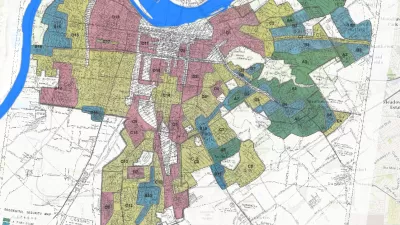
The Mapping Inequality website documents how the liberal ideals of the New Deal devolved into discrimination and inequality.
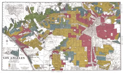
"The maps in this post are part of a grim history," according to an article by Greg Miller. "They were created by a government program in the 1930s and played a role in keeping African Americans and other minorities from owning property in American cities, thereby leaving an indelible mark on the racial and economic history of the United States."
The Mapping Inequality project has gathered these maps and documents, the work of the Home Owners' Loan Corporation (HOLC) during the Great Depression, and placed them online.
Miller explains more of the redlining history of the HOLC, while also sampling specific case studies from cities included in the Mapping Inequality archive—cities such as Los Angeles, Seattle, Wichita, and Portland.
As acknowledged on the Mapping Inequality website, the project combines the work of researchers and students at the University of Richmond, the University of Maryland, Virginia Tech, and Johns Hopkins University.
FULL STORY: Newly Released Maps Show How Housing Discrimination Happened

Reporters Go Undercover to Identify Housing Discrimination
A three-year investigation of the real estate industry on Long Island reveals rampant discriminatory practices and an industry complicit in the segregation of the communities that comprise the region.
Study: Historical Redlining Maps No Longer a Proxy for Black America
Black Americans have moved on from formerly redlined neighborhoods, and other minorities and whites have moved in. The wave of presidential campaigns that have based housing policy proposals on redlining maps might be misguided as a result.
Seattle Exhibit Grapples With Redlining Past and Present
A creative exhibit highlights how redlining and racist exclusion persist today.

Pennsylvania Mall Conversion Bill Passes House
If passed, the bill would promote the adaptive reuse of defunct commercial buildings.

Planning for Accessibility: Proximity is More Important than Mobility
Accessibility-based planning minimizes the distance that people must travel to reach desired services and activities. Measured this way, increased density can provide more total benefits than increased speeds.

World's Largest Wildlife Overpass In the Works in Los Angeles County
Caltrans will soon close half of the 101 Freeway in order to continue construction of the Wallis Annenberg Wildlife Crossing near Agoura Hills in Los Angeles County.

Eviction Looms for Low-Income Tenants as Rent Debt Rises
Nonprofit housing operators across the country face almost $10 billion in rent debt.

Brightline West Breaks Ground
The high-speed rail line will link Las Vegas and the Los Angeles area.

Colorado Bans No-Fault Evictions
In most cases, landlords must provide a just cause for evicting tenants.
City of Costa Mesa
Licking County
Barrett Planning Group LLC
HUD's Office of Policy Development and Research
Mpact Transit + Community
HUD's Office of Policy Development and Research
Tufts University, Department of Urban and Environmental Policy & Planning
City of Universal City TX
ULI Northwest Arkansas
Urban Design for Planners 1: Software Tools
This six-course series explores essential urban design concepts using open source software and equips planners with the tools they need to participate fully in the urban design process.
Planning for Universal Design
Learn the tools for implementing Universal Design in planning regulations.