


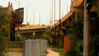
A project to fill-in the Inner Loop in Rochester, New York is underway. It took a lot of contemporary planning to undo this mistake of mid-century planning.

"Realizing the devastating effect urban freeways have had on downtowns across the U.S., many cities are now contemplating some form of freeway removal," according to an article by Norman Garrick. "Most of these discussions haven’t gotten very far, but in Rochester, New York, officials have moved beyond the talking phase and are actually taking action."
Work is already underway in covering over the ditch that once gave cars access to the Inner Loop at the expense of Rochester's neighborhoods.
Garrick relates a history of the planning and political work that preceded the demise of I-490—dating back to the 1990s. "This two-decade long effort culminated in the city finally winning a TIGER grant for over $17 million from the USDOT for the removal of a 2/3-mile long stretch of the Inner Loop," adds Garrick. "The total cost of the project: $22 million."
Garrick (who was one of the researchers behind a study that made news earlier this year for finding the strongest evidence yet "that parking is a 'likely cause' of increased driving") also provides a few lessons in overthrowing the 20th century paradigms that put cars first.
FULL STORY: Burying a 1950s Planning Disaster
Ten 'Freeways Without Futures'
The Congress for New Urbanism has once again released on if its signature efforts: the Freeways Without Futures report that assumes urban freeways were a mistake of 20th century planning and engineering and advocates for a new approach.
Economic Justice Includes Highway Removals
A $435 billion "economic justice" bill proposed by Democrats in the U.S. Senate includes $10 billion for projects that remove highways and build community-oriented assets in their place.
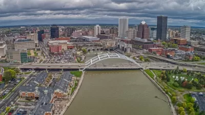
Rochester Shows Possible Future for Former Highways
A former freeway is undergoing a massive redevelopment that goes beyond highway removal to reconnect and revitalize surrounding areas.

Pennsylvania Mall Conversion Bill Passes House
If passed, the bill would promote the adaptive reuse of defunct commercial buildings.

Coming Soon to Ohio: The Largest Agrivoltaic Farm in the US
The ambitious 6,000-acre project will combine an 800-watt solar farm with crop and livestock production.

World's Largest Wildlife Overpass In the Works in Los Angeles County
Caltrans will soon close half of the 101 Freeway in order to continue construction of the Wallis Annenberg Wildlife Crossing near Agoura Hills in Los Angeles County.

California Grid Runs on 100% Renewable Energy for Over 9 Hours
The state’s energy grid was entirely powered by clean energy for some portion of the day on 37 out of the last 45 days.

New Forecasting Tool Aims to Reduce Heat-Related Deaths
Two federal agencies launched a new, easy-to-use, color-coded heat warning system that combines meteorological and medical risk factors.

AI Traffic Management Comes to Dallas-Fort Worth
Several Texas cities are using an AI-powered platform called NoTraffic to help manage traffic signals to increase safety and improve traffic flow.
City of Costa Mesa
Licking County
Barrett Planning Group LLC
HUD's Office of Policy Development and Research
Mpact Transit + Community
HUD's Office of Policy Development and Research
Tufts University, Department of Urban and Environmental Policy & Planning
City of Universal City TX
ULI Northwest Arkansas
Urban Design for Planners 1: Software Tools
This six-course series explores essential urban design concepts using open source software and equips planners with the tools they need to participate fully in the urban design process.
Planning for Universal Design
Learn the tools for implementing Universal Design in planning regulations.