


A case study in New York's response to the Hurricane Sandy flooding in the neighborhoods of Coney Island and Gravesend.
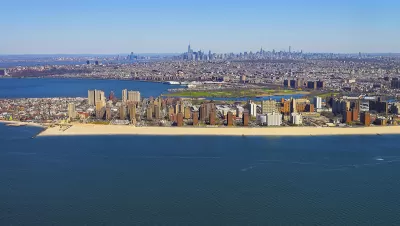
The New York Economic Development Corporation recently announced its release of the Coney Island Creek Resiliency Study, described as "a critical component to resiliency planning for the communities around Coney Island Creek."
"During Hurricane Sandy, Coney Island Creek was the main source of inundation for much of the Gravesend and Coney Island neighborhoods. Low edges and topography contributed to 'backdoor' flooding that caused enormous damage," according to the announcement.
The "study investigated several strategies to mitigate upland flooding, improve waterfront open space, strengthen neighborhood connections, enhance infrastructure, and provide opportunity for economic development around the Creek." A key finding of the study was the tie continued plans to study and plan for flood risk along the creek into broader regional efforts by the city and states of New York, along with the United States Army Corps of Engineers.
FULL STORY: Coney Island Creek Resiliency Study
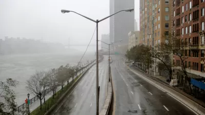
Saving Lower Manhattan
A debate over how to protect the East River waterfront from Sandy-level flooding and storm damage has delayed the project as community activists decry the city's last-minute change of plans.

In Battery Park City, Public Infrastructure Meets Climate Resilience
A massive project underway in Lower Manhattan seeks to protect the shoreline from future flooding and mitigate the effects of climate change and rising sea levels.

Net Zero Development Coming to New York City
The project, which relies largely on geothermal energy to minimize its carbon footprint, will bring affordable housing and boost storm resilience to an area devastated by Hurricane Sandy.

Pennsylvania Mall Conversion Bill Passes House
If passed, the bill would promote the adaptive reuse of defunct commercial buildings.

Coming Soon to Ohio: The Largest Agrivoltaic Farm in the US
The ambitious 6,000-acre project will combine an 800-watt solar farm with crop and livestock production.

World's Largest Wildlife Overpass In the Works in Los Angeles County
Caltrans will soon close half of the 101 Freeway in order to continue construction of the Wallis Annenberg Wildlife Crossing near Agoura Hills in Los Angeles County.

California Grid Runs on 100% Renewable Energy for Over 9 Hours
The state’s energy grid was entirely powered by clean energy for some portion of the day on 37 out of the last 45 days.

New Forecasting Tool Aims to Reduce Heat-Related Deaths
Two federal agencies launched a new, easy-to-use, color-coded heat warning system that combines meteorological and medical risk factors.

AI Traffic Management Comes to Dallas-Fort Worth
Several Texas cities are using an AI-powered platform called NoTraffic to help manage traffic signals to increase safety and improve traffic flow.
City of Costa Mesa
Licking County
Barrett Planning Group LLC
HUD's Office of Policy Development and Research
Mpact Transit + Community
HUD's Office of Policy Development and Research
Tufts University, Department of Urban and Environmental Policy & Planning
City of Universal City TX
ULI Northwest Arkansas
Urban Design for Planners 1: Software Tools
This six-course series explores essential urban design concepts using open source software and equips planners with the tools they need to participate fully in the urban design process.
Planning for Universal Design
Learn the tools for implementing Universal Design in planning regulations.