


Emily Badger, writing for The Washington Post's Wonkblog, doesn't let planners off the hook for the racist history of highway planning around the country.
"As scenes of protest, [highways] are part of the oppression — if also the most disruptive places to call attention to it," writes Emily Badger in a recent article that places 20th century planning at the center of the ongoing cycle of racial conflict gripping the United States.
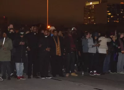
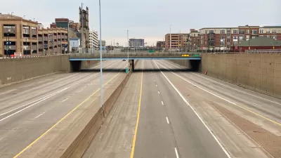
Recent blockades follow graphic videos showing the deaths of Philando Castile in Falcon Heights, Minnesota and Alton Sterling in Baton Rouge, Louisiana at the hands of police officers. In response, "Protesters in Chicago have blocked Lake Shore Drive. In New York, they've gnarled traffic on the Brooklyn Bridge. In Washington, they've targeted the 14th Street Bridge."
According to Badger, a forthcoming study examined the tendency of Black Lives Matter protestors to stage their protests by shutting down transportation infrastructure:
Researchers at the Rudin Center for Transportation at New York University, in a forthcoming study, counted more than 1,400 protests in nearly 300 U.S. and international cities related to the Black Lives Matter movement from November 2014 through May 2015. Half or more of the protests in that time in Saint Louis, Los Angeles, San Francisco and Oakland, Calif., wound up shutting down transportation infrastructure.
Badger's article responds to a statement by Atlanta Mayor Kasim Reed, who invoked the name of Dr. Martin Luther King Jr. when faced with the prospect of protesters taking over that city's highways: "The only thing I ask is that they not take the freeways. Dr. King would never take a freeway," said Reed.
Badger's response is to document the racist history of highways, and the ongoing consequences suffered by black and minority communities as a result of highways.
The resulting highways were then meant to speed whites who'd moved to the suburbs back and forth to jobs and attractions downtown, leapfrogging minority communities along the way….they still serve this function today. And often, highways that passed through black communities weren't planned with on- and off-ramps to them.
Notice how the word choice of "planned" in the above passage. And now a description of the consequences of that history of planning, which seems strikingly at odds with the intended purposes of contemporary planning purposes.
Even without knowing this history, the consequences of it in cities are evident today, feeding the frustration of communities that have been segregated and separated from schools or parks or prompt ambulance access.
Badger also notes that David Levinson has written a blog post calling for transportation planners to say "Not In Our Name" in response to the use of traffic rules and regulations as a "pretext for enforcing the crime of driving while black."
Now the question is: How far are planners going now to undo the racist mistakes of the past, while making sure they don't happen again?
FULL STORY: Why highways have become the center of civil rights protest
How Policymakers Are Grappling With the Racist Legacy of Urban Freeways
In Michigan, the state's Department of Transportation is looking for ways to mitigate the damage caused by decades of urban renewal policies and reconnect neighborhoods cut off from amenities and opportunities by highway projects.
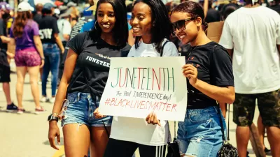
White House Marks Juneteenth by Pushing for Zoning Reforms
On a holiday that commemorates the end of slavery in the United States, the White House marked the occasion by discussion exclusionary zoning.
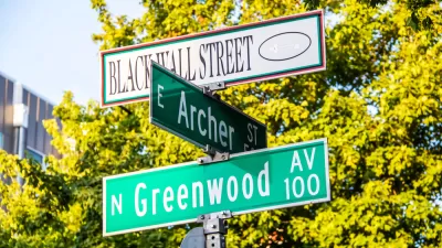
Black Wall Street's Second Destruction
After the Tulsa Race Massacre, Greenwood rebuilt strong. Then came "urban renewal."

Depopulation Patterns Get Weird
A recent ranking of “declining” cities heavily features some of the most expensive cities in the country — including New York City and a half-dozen in the San Francisco Bay Area.

California Exodus: Population Drops Below 39 Million
Never mind the 40 million that demographers predicted the Golden State would reach by 2018. The state's population dipped below 39 million to 38.965 million last July, according to Census data released in March, the lowest since 2015.

Chicago to Turn High-Rise Offices into Housing
Four commercial buildings in the Chicago Loop have been approved for redevelopment into housing in a bid to revitalize the city’s downtown post-pandemic.

Google Maps Introduces New Transit, EV Features
It will now be easier to find electric car charging stations and transit options.

Ohio Lawmakers Propose Incentivizing Housing Production
A proposed bill would take a carrot approach to stimulating housing production through a grant program that would reward cities that implement pro-housing policies.

Chicago Awarded $2M Reconnecting Communities Grant
Community advocates say the city’s plan may not do enough to reverse the negative impacts of a major expressway.
City of Costa Mesa
Licking County
Barrett Planning Group LLC
HUD's Office of Policy Development and Research
Mpact Transit + Community
HUD's Office of Policy Development and Research
City of Universal City TX
ULI Northwest Arkansas
Town of Zionsville
Urban Design for Planners 1: Software Tools
This six-course series explores essential urban design concepts using open source software and equips planners with the tools they need to participate fully in the urban design process.
Planning for Universal Design
Learn the tools for implementing Universal Design in planning regulations.