


Montreal will include one less elevated highway—so long Bonaventure Expressway.
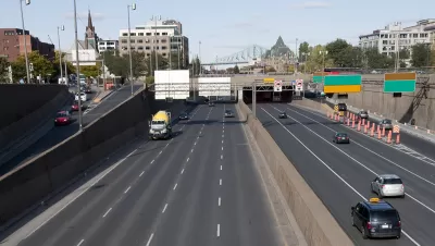
Andy Riga reports: "Montreal started tearing down its portion of the elevated Bonaventure Expressway this week, promising to replace it with two boulevards with a series of green spaces between them, by September 2017."
The expressway is owned partly by Ottawa (between the Champlain Bridge and the Lachine Canal) and partly by Montreal (from the canal to downtown). The elevated expressway was serving about 25,000 drivers per day prior to being closed for demolition, according to Riga.
The two boulevards running parallel to the elevated expressway will be reconfigured to handle the traffic, though with two fewer lanes in total than the previous configuration. The city aims to make the changes without increasing congestion by implementing "an 'intelligent transportation system' that will let the city adjust the timing of traffic lights according to traffic conditions." A proposed light rail line would also connect downtown to the South Shore neighborhoods formerly served by the expressway.
Planetizen first reported on the proposed demolition of the Bonaventure Expressway in December 2014.
FULL STORY: Say goodbye to elevated stretch of Bonaventure Expressway

Montreal to Tear Down Elevated Bonaventure Expressway
The city of Montreal announced final plans to tear down an elevated highway and replace it with an urban boulevard.
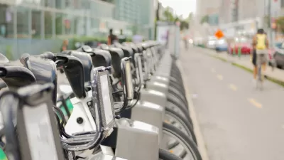
Montreal Shatters Stereotypes on Cold Weather Biking
A combination of infrastructure, connectivity, and quality equipment has made the Canadian city’s bike share system successful despite frigid winters and challenging geography.

Montreal Developers Prefer to Pay Rather Than Build Affordable Housing
Housing advocates say a 2021 bylaw aimed at building more affordable housing units is too lenient, letting developers opt out by paying a fee some consider too low.

Depopulation Patterns Get Weird
A recent ranking of “declining” cities heavily features some of the most expensive cities in the country — including New York City and a half-dozen in the San Francisco Bay Area.

California Exodus: Population Drops Below 39 Million
Never mind the 40 million that demographers predicted the Golden State would reach by 2018. The state's population dipped below 39 million to 38.965 million last July, according to Census data released in March, the lowest since 2015.

Chicago to Turn High-Rise Offices into Housing
Four commercial buildings in the Chicago Loop have been approved for redevelopment into housing in a bid to revitalize the city’s downtown post-pandemic.

Chicago Awarded $2M Reconnecting Communities Grant
Community advocates say the city’s plan may not do enough to reverse the negative impacts of a major expressway.

New Park Opens in the Santa Clarita Valley
The City of Santa Clarita just celebrated the grand opening of its 38th park, the 10.5-acre Skyline Ranch Park.

U.S. Supreme Court: California's Impact Fees May Violate Takings Clause
A California property owner took El Dorado County to state court after paying a traffic impact fee he felt was exorbitant. He lost in trial court, appellate court, and the California Supreme Court denied review. Then the U.S. Supreme Court acted.
City of Costa Mesa
Licking County
Barrett Planning Group LLC
HUD's Office of Policy Development and Research
Mpact Transit + Community
HUD's Office of Policy Development and Research
City of Universal City TX
ULI Northwest Arkansas
Town of Zionsville
Urban Design for Planners 1: Software Tools
This six-course series explores essential urban design concepts using open source software and equips planners with the tools they need to participate fully in the urban design process.
Planning for Universal Design
Learn the tools for implementing Universal Design in planning regulations.