


As urban economies continue their upward trajectory, residents of counties once considered rural are commuting to cities. This has had both negative and positive effects on the communities in question.
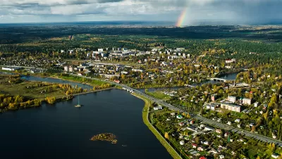
For much of the past century, Hamilton Lombard writes, sprawl drove metropolitan growth. Now it's different. "[...] A major reason for this geographic growth today is that as the urban cores of metropolitan areas have grown larger, they have attracted a rising number of commuters from nearby rural counties, in many cases causing the rural counties to become part of their metropolitan area."
Much has been made of metropolitan corridors comprising urban centers as well as their suburbs and exurbs, which often blend together to form a vast, sprawled-out regional population center. When rural counties join these metro areas, they're often experiencing in-county job losses as many residents stay put and endure longer commutes.
This isn't always a uniformly bad thing. "The shift away from an economy centered on agriculture and manufacturing has been difficult for many communities, but it also has had its benefits. Farming is an unreliable business, dependent on weather and volatile commodity prices. Factories have not always provided stable jobs either."
Highlighting the continued importance of long-distance transportation infrastructure, formerly rural areas can benefit from connections to a wider metropolis. "Though becoming part of a metropolitan area has not prevented job losses in most of these counties, being connected with a larger, more diversified metropolitan economy has typically meant more economic stability than in the past."
FULL STORY: The metropolitanization of rural America
COVID and the Urban-Rural Divide
Researchers at the University of Iowa analyzed COVID-19 death data in rural and metropolitan counties and found that rural Americans have died at twice the rate as those living in more urbanized counties. The health divide will only widen.

Poor Suburbs Struggle with Job Sprawl
Although unemployment has declined, according to this report commutes are getting longer. "Job sprawl" often plagues minority and poor areas where housing is more affordable.
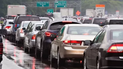
'Jobs Sprawl' Plagues Cleveland Commutes
Research from Brookings puts Cleveland in last place for improving access to jobs from 2000 through 2012. And jobs sprawl is up throughout the rest of the country as well.

Pennsylvania Mall Conversion Bill Passes House
If passed, the bill would promote the adaptive reuse of defunct commercial buildings.

Planning for Accessibility: Proximity is More Important than Mobility
Accessibility-based planning minimizes the distance that people must travel to reach desired services and activities. Measured this way, increased density can provide more total benefits than increased speeds.

World's Largest Wildlife Overpass In the Works in Los Angeles County
Caltrans will soon close half of the 101 Freeway in order to continue construction of the Wallis Annenberg Wildlife Crossing near Agoura Hills in Los Angeles County.

Eviction Looms for Low-Income Tenants as Rent Debt Rises
Nonprofit housing operators across the country face almost $10 billion in rent debt.

Brightline West Breaks Ground
The high-speed rail line will link Las Vegas and the Los Angeles area.

Colorado Bans No-Fault Evictions
In most cases, landlords must provide a just cause for evicting tenants.
City of Costa Mesa
Licking County
Barrett Planning Group LLC
HUD's Office of Policy Development and Research
Mpact Transit + Community
HUD's Office of Policy Development and Research
Tufts University, Department of Urban and Environmental Policy & Planning
City of Universal City TX
ULI Northwest Arkansas
Urban Design for Planners 1: Software Tools
This six-course series explores essential urban design concepts using open source software and equips planners with the tools they need to participate fully in the urban design process.
Planning for Universal Design
Learn the tools for implementing Universal Design in planning regulations.