


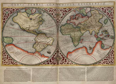
Typical world maps badly misrepresent the size of countries; a new web app shows their true scale.
The True Size Of is an interactive app that seeks to improve our skewed sense of global geography by correcting the world map.
The web app allows users to drag a country to another part of the map. The country's size and shape will change until it compares accurately to its new location.
For a little background on why "the world's most ubiquitous map" is so distorted, Liz Stinson at Wired explains:
The Mercator projection is an inherently flawed design. It exaggerates the size of countries closest to the poles while depicting size most faithfully at the equator. Though it was once a handy navigational tool for sailors, the map has instilled in the rest of us a gross misunderstanding of geography and relative country size.
FULL STORY: Fascinating App Shows You How Misleading Maps Can Be
Mapped: Every Building in the United States
Using data from Microsoft, the New York Times has published an online map showing the placement of every building in the country, in a simple black and white format.

The Importance of Geographic Literacy
Maps are still an important tool in teaching kids to be global citizens.
Putting Alternative Fuel Stations on the Map
Yesterday, the U.S. Department of Energy released an interactive map displaying thousands of alternative fuel stations around the nation.

Pennsylvania Mall Conversion Bill Passes House
If passed, the bill would promote the adaptive reuse of defunct commercial buildings.

Planning for Accessibility: Proximity is More Important than Mobility
Accessibility-based planning minimizes the distance that people must travel to reach desired services and activities. Measured this way, increased density can provide more total benefits than increased speeds.

World's Largest Wildlife Overpass In the Works in Los Angeles County
Caltrans will soon close half of the 101 Freeway in order to continue construction of the Wallis Annenberg Wildlife Crossing near Agoura Hills in Los Angeles County.

Eviction Looms for Low-Income Tenants as Rent Debt Rises
Nonprofit housing operators across the country face almost $10 billion in rent debt.

Brightline West Breaks Ground
The high-speed rail line will link Las Vegas and the Los Angeles area.

Colorado Bans No-Fault Evictions
In most cases, landlords must provide a just cause for evicting tenants.
City of Costa Mesa
Licking County
Barrett Planning Group LLC
HUD's Office of Policy Development and Research
Mpact Transit + Community
HUD's Office of Policy Development and Research
Tufts University, Department of Urban and Environmental Policy & Planning
City of Universal City TX
ULI Northwest Arkansas
Urban Design for Planners 1: Software Tools
This six-course series explores essential urban design concepts using open source software and equips planners with the tools they need to participate fully in the urban design process.
Planning for Universal Design
Learn the tools for implementing Universal Design in planning regulations.