


A photo series documents some of the many different U.S. streets named to honor MLK.
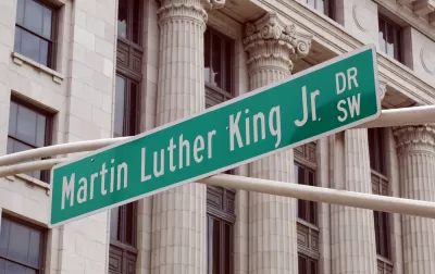
CityLab shares selections from photographer Susan Berger, who set out to capture some of the 900+ streets in the United States named for Martin Luther King, Jr.
Berger reflects on the differences she noticed in the upkeep and centrality of those streets from city to city.
For instance:
Berger made a point to visit those cities most closely associated with the Civil Rights movements. In some of those places, the placement of MLK streets testifies to his enduring local significance. In Little Rock, Martin Luther King Dr. runs right up against the state capitol buildings; in Atlanta, it’s a long street that cuts through the entire swath of the city, from government buildings to residential neighborhoods, intersecting a range of socioeconomic levels.
But research has also shown that streets named for MLK tend to be associated with "lower incomes and higher rates of racial segregation than city-wide and national norms":
Some of Berger’s photographs, like those she took in Houston, Texas, reflect this truth in broken chain-link fences and abandoned parking lots. In these neighborhoods, the MLK-named streets serve as a reminder of the man himself, and all that he did and dreamed of. “At the same time, though, you look at the neighborhood and say: what has been accomplished? To what extent had that dream been realized?” Berger says.
Over the years, there have been efforts by non-profits to revitalize those streets; the city of Atlanta also recently took steps to transform its MLK Drive.
FULL STORY: Photographing the Streets Named for Martin Luther King Jr.
Revitalizing MLK Streets to Better Honor Their Namesake
Across the U.S., hundreds of streets are named in honor of Dr. Martin Luther King Jr. Unfortunately, many reflect the poverty and segregation that King fought to reverse. A non-profit is trying to transform them into sources of pride and inspiration.
Climate Justice Advocate Named One of TIME's Women of the Year
Jacqueline Patterson has dedicated her career to intersectional approaches to systems change and social and environmental justice.

Philadelphia Transit Officials Honor Civil Rights Activists
A ceremony held Monday celebrated people who contributed to the desegregation of public transit.

Pennsylvania Mall Conversion Bill Passes House
If passed, the bill would promote the adaptive reuse of defunct commercial buildings.

World's Largest Wildlife Overpass In the Works in Los Angeles County
Caltrans will soon close half of the 101 Freeway in order to continue construction of the Wallis Annenberg Wildlife Crossing near Agoura Hills in Los Angeles County.

U.S. Supreme Court: California's Impact Fees May Violate Takings Clause
A California property owner took El Dorado County to state court after paying a traffic impact fee he felt was exorbitant. He lost in trial court, appellate court, and the California Supreme Court denied review. Then the U.S. Supreme Court acted.

California Grid Runs on 100% Renewable Energy for Over 9 Hours
The state’s energy grid was entirely powered by clean energy for some portion of the day on 37 out of the last 45 days.

New Forecasting Tool Aims to Reduce Heat-Related Deaths
Two federal agencies launched a new, easy-to-use, color-coded heat warning system that combines meteorological and medical risk factors.

AI Traffic Management Comes to Dallas-Fort Worth
Several Texas cities are using an AI-powered platform called NoTraffic to help manage traffic signals to increase safety and improve traffic flow.
City of Costa Mesa
Licking County
Barrett Planning Group LLC
HUD's Office of Policy Development and Research
Mpact Transit + Community
HUD's Office of Policy Development and Research
Tufts University, Department of Urban and Environmental Policy & Planning
City of Universal City TX
ULI Northwest Arkansas
Urban Design for Planners 1: Software Tools
This six-course series explores essential urban design concepts using open source software and equips planners with the tools they need to participate fully in the urban design process.
Planning for Universal Design
Learn the tools for implementing Universal Design in planning regulations.