


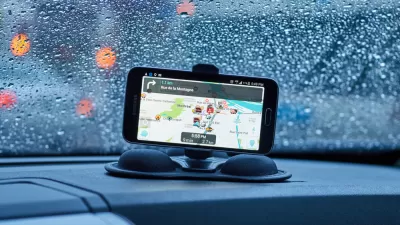
Accounts of disgruntled residents responding by any means necessary to the flood of cars beckoned by the whims of navigation apps like Waze are spreading across the country.

Steve Hendrix reports on the ongoing battle between residents of residential streets and navigation apps like Waze. Hendrix specifically cites the example of Timothy Connor, who lives in Takoma Park, Maryland and has become so frustrated by the number of cars on his street as a result of a nearby street repair.
Hendrix reports that Connor "borrowed a tactic he read about from the car wars of Southern California and other traffic-weary regions: He became a Waze impostor. Every rush hour, he went on the Google-owned social-media app and posted false reports of a wreck, speed trap or other blockage on his street, hoping to deflect some of the flow."
Eventually Waze discovered Connor's tactic and stopped registering his reports, "[making] Connor a casualty in the social-media skirmishes erupting across the country as neighborhoods try to contend with suddenly savvy drivers finding their way on routes that were once all but secret."
Hendrix looks around the country for more examples of the methods by which cities and residents are countering the traffic effects of navigation algorithms. Hendrix also reports Waze's response, both in suspending users suspected of "tampering with the map" and in adding new features to the app, like "alerts about school zones and other slow-speed zones…"
FULL STORY: Traffic-weary homeowners and Waze are at war, again. Guess who’s winning?
Cities Seeking New Weapons in the Battle Against Waze-Induced Traffic
Los Altos, California has erected a new roadblock in its ongoing effort to keep drivers from cutting through residential neighborhoods, beckoned by the popular navigation app Waze.
Flooded With Navigation App Users, a Town Closes Its Streets
Navigation apps like Waze often reroute drivers onto residential streets that would be quiet otherwise. With some residents unable to leave their driveways, the New Jersey borough of Leonia has taken an extreme measure against the problem.
Are Traffic Apps More a Problem Than a Solution?
The companies behind navigation apps say they want to decrease congestion in cities. But a tool that is essentially designed to help individuals isn’t going to provide a collective benefit.

Pennsylvania Mall Conversion Bill Passes House
If passed, the bill would promote the adaptive reuse of defunct commercial buildings.

Coming Soon to Ohio: The Largest Agrivoltaic Farm in the US
The ambitious 6,000-acre project will combine an 800-watt solar farm with crop and livestock production.

World's Largest Wildlife Overpass In the Works in Los Angeles County
Caltrans will soon close half of the 101 Freeway in order to continue construction of the Wallis Annenberg Wildlife Crossing near Agoura Hills in Los Angeles County.

California Grid Runs on 100% Renewable Energy for Over 9 Hours
The state’s energy grid was entirely powered by clean energy for some portion of the day on 37 out of the last 45 days.

New Forecasting Tool Aims to Reduce Heat-Related Deaths
Two federal agencies launched a new, easy-to-use, color-coded heat warning system that combines meteorological and medical risk factors.

AI Traffic Management Comes to Dallas-Fort Worth
Several Texas cities are using an AI-powered platform called NoTraffic to help manage traffic signals to increase safety and improve traffic flow.
City of Costa Mesa
Licking County
Barrett Planning Group LLC
HUD's Office of Policy Development and Research
Mpact Transit + Community
HUD's Office of Policy Development and Research
Tufts University, Department of Urban and Environmental Policy & Planning
City of Universal City TX
ULI Northwest Arkansas
Urban Design for Planners 1: Software Tools
This six-course series explores essential urban design concepts using open source software and equips planners with the tools they need to participate fully in the urban design process.
Planning for Universal Design
Learn the tools for implementing Universal Design in planning regulations.