


While a federally-funded network of bike paths is in the works elsewhere in the city, the Major Taylor Trail gets little use from Chicago residents. The main problems are a lack of awareness and the South Side's fearsome reputation.
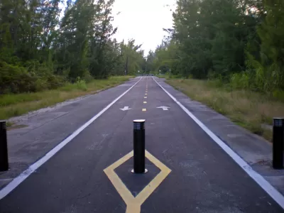
Many Chicago bike enthusiasts frequent the 606, a popular path following an old railroad bed on the Northwest Side. But to the south, the Major Taylor Trail gets little love, though it was built eight years earlier. Mary Wisniewski discusses why that is.
In many respects, Chicagoan cyclists enjoy a widening array of options. One of them is the Cal-Sag trail and the adjacent 86-mile Southland Century bike loop. "The Major Taylor will link to the popular Cal-Sag Trail, being built with $21 million of mostly federal funds. [...] If all goes as planned, in 2018 the Cal-Sag will be the northern leg of a mostly off-road loop that will include the Old Plank Road, Thorn Creek, Centennial and I&M Canal trails and the Burnham and Pennsy greenways."
The biggest drawback for the Major Taylor is crime, or the perception of it. Snaking through low-slung less well-off suburbs of color, the Major Taylor Trail feels deserted. "The trail's solitude adds to the feeling of insecurity: The southern end leading to the Little Calumet River is lovely but on a quiet weekday feels like Fangorn Forest in 'The Lord of the Rings' — vaguely unsettling."
More users means a safer trail, but users won't show up until they think the trail's safe. A catch-22. Meanwhile, "Supporters keep publicizing the trail through the bike community, social media and holding group events to get more people to try it."
FULL STORY: Why the Major Taylor isn't as well-known — or used — as The 606

Advocates Champion the Great Western Trail
A Chicago walking and biking trail along a former railroad right-of-way has been a labor of love for local residents.
A National Bike Trail Network Is Slowly Growing
Around the United States, new bike lanes and trails are connecting communities via two (or three) wheels.

Chicago Had a Banner Year for Bike Infrastructure
The city built more bike lane miles in 2023 than in any previous year.

Pennsylvania Mall Conversion Bill Passes House
If passed, the bill would promote the adaptive reuse of defunct commercial buildings.

World's Largest Wildlife Overpass In the Works in Los Angeles County
Caltrans will soon close half of the 101 Freeway in order to continue construction of the Wallis Annenberg Wildlife Crossing near Agoura Hills in Los Angeles County.

U.S. Supreme Court: California's Impact Fees May Violate Takings Clause
A California property owner took El Dorado County to state court after paying a traffic impact fee he felt was exorbitant. He lost in trial court, appellate court, and the California Supreme Court denied review. Then the U.S. Supreme Court acted.

Coming Soon to Ohio: The Largest Agrivoltaic Farm in the US
The ambitious 6,000-acre project will combine an 800-watt solar farm with crop and livestock production.

New York’s Deadliest Neighborhoods for Pedestrians
Pedestrian deaths rose last year, but remain below pre-2020 levels.

Eviction Looms for Low-Income Tenants as Rent Debt Rises
Nonprofit housing operators across the country face almost $10 billion in rent debt.
City of Costa Mesa
Licking County
Barrett Planning Group LLC
HUD's Office of Policy Development and Research
Mpact Transit + Community
HUD's Office of Policy Development and Research
Tufts University, Department of Urban and Environmental Policy & Planning
City of Universal City TX
ULI Northwest Arkansas
Urban Design for Planners 1: Software Tools
This six-course series explores essential urban design concepts using open source software and equips planners with the tools they need to participate fully in the urban design process.
Planning for Universal Design
Learn the tools for implementing Universal Design in planning regulations.