


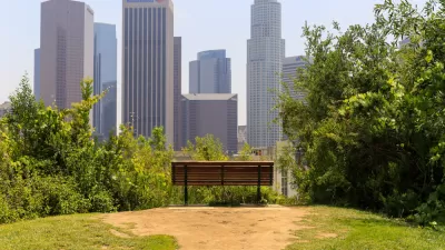
For the second time in its history, Louisville completed an ambitious and massive park planning and design process on its suburban fringe. The fringe today is just a bit farther out than it was in Olmsted's day.

Jen Kinney writes that this month in Louisville, "nonprofit 21st Century Parks is celebrating the completion of a new greenway on Louisville’s now expanded limits, the city’s first major public-private partnership to construct new parks." All told, the Parklands of Floyds Fork cost $125 million, creating 2,000 acres and nearly 20 miles of continuous parkways.
As Kinney notes, the new park is an echo of the park planning of Louisville's past: over 100 years ago, "Frederick Law Olmsted designed a system of 18 parks linked by 14.5 miles of greenery-ed boulevards around the then-urban edges of Louisville…"
Now the suburban edge of the city is decidedly farther out from the urban core, on land requiring a very involved series of transactions to assemble. According to Kinney, "21st Century Parks engaged in 80 separate land transactions with a variety of owners to piece together the park over the course of eight years. None of the land was acquired by eminent domain or condemnation."
The article includes more details about the amenities and facilities included in the completed park. City officials are expecting 2 million visitors to the park this year.
FULL STORY: Louisville Looks to the Edges for New Parks, Once Again

Using Cellphone and Fitness App Data for Park Planning
Data from smartphone apps and fitness trackers are helping planners to better understand park usage patterns and plan for new and improved parks.

Using Technology to Advance Park Planning
A variety of new tools can help with community engagement and data collection and analysis for park planning projects.
A New Approach to Park Equity
A new approach prioritizes investments in the capacity of people closest to the problem to achieve population-level impacts.

Pennsylvania Mall Conversion Bill Passes House
If passed, the bill would promote the adaptive reuse of defunct commercial buildings.

World's Largest Wildlife Overpass In the Works in Los Angeles County
Caltrans will soon close half of the 101 Freeway in order to continue construction of the Wallis Annenberg Wildlife Crossing near Agoura Hills in Los Angeles County.

U.S. Supreme Court: California's Impact Fees May Violate Takings Clause
A California property owner took El Dorado County to state court after paying a traffic impact fee he felt was exorbitant. He lost in trial court, appellate court, and the California Supreme Court denied review. Then the U.S. Supreme Court acted.

New Forecasting Tool Aims to Reduce Heat-Related Deaths
Two federal agencies launched a new, easy-to-use, color-coded heat warning system that combines meteorological and medical risk factors.

AI Traffic Management Comes to Dallas-Fort Worth
Several Texas cities are using an AI-powered platform called NoTraffic to help manage traffic signals to increase safety and improve traffic flow.

Podcast: Addressing the Root Causes of Transit Violence
Deploying transit police is a short-term fix. How can transit agencies build sustainable safety efforts?
City of Costa Mesa
Licking County
Barrett Planning Group LLC
HUD's Office of Policy Development and Research
Mpact Transit + Community
HUD's Office of Policy Development and Research
Tufts University, Department of Urban and Environmental Policy & Planning
City of Universal City TX
ULI Northwest Arkansas
Urban Design for Planners 1: Software Tools
This six-course series explores essential urban design concepts using open source software and equips planners with the tools they need to participate fully in the urban design process.
Planning for Universal Design
Learn the tools for implementing Universal Design in planning regulations.