


Google Maps has changed a lot since its quick rise to ubiquity. An intrepid blogger digs into the nitty gritty of how the mapping platform has changed, and the consequences of Google's cartography for how the public perceives the world.

Justin O'Beirne examines the effects of several years of changes to the cartography of Google Maps—perhaps the most popular of the online mapping programs.
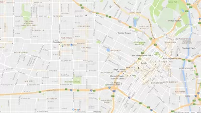
Browsing Google Maps over the past year or so, I've often thought that there are fewer labels than there used to be. Google's cartography was revamped three years ago – but surely this didn't include a reduction in labels? Rather, the sparser maps appear to be a recent development.
After digging into side-by-side comparisons of screengrabs taken from Google Maps in 2010 and 2016, O'Beirne notices obvious, and consequential, changes. For instance, Google Maps now has fewer city labels but more roads. In effect, explains O'Beirne, Google Maps has become a network map. "The cities are the nodes. And the roads are the paths between the nodes." [Emphasis in the original.]
O'Beirne concludes that both the 2010 and the 2016 versions of Google Maps suffer from a lack of balance between cities and roads. He does, however, offer an example of a map that achieves this balance more effectively, and even imagines what a Google map of Chicago would look like if it were balanced correctly.
FULL STORY: WHAT HAPPENED TO GOOGLE MAPS?

New Google Map Layer Shows COVID-19 Infection Rates
A new layer showing the seven-day average of confirmed COVID-19 cases started rolling out to Android and iPhones last week.
Google Maps Update Opens New Access to Mobility and Culture
Google Maps and other navigation and mapping apps have done a lot to inspire and educate people to make the most of their surroundings. New changes to the Google Maps app will add new functionality for those purposes.
Does the Evolution of Smartphones Come at the Expense of 'Spatial Thinking'?
Are smartphones supplementing the capacity of humans to think spatially, such that future generations might lose fundamental cognitive abilities?

Pennsylvania Mall Conversion Bill Passes House
If passed, the bill would promote the adaptive reuse of defunct commercial buildings.

Planning for Accessibility: Proximity is More Important than Mobility
Accessibility-based planning minimizes the distance that people must travel to reach desired services and activities. Measured this way, increased density can provide more total benefits than increased speeds.

World's Largest Wildlife Overpass In the Works in Los Angeles County
Caltrans will soon close half of the 101 Freeway in order to continue construction of the Wallis Annenberg Wildlife Crossing near Agoura Hills in Los Angeles County.

Amtrak Takes Lead on Texas Central Rail
The high-speed rail project isn’t a done deal, but if it moves forward, trains could begin operating in 2030.

Maine Approves Rent Relief Program
Legislators hope the assistance program will help struggling low-income households avoid eviction.

How Transit Architecture Impacts Real and Perceived Safety
More than a third of Americans believe major transit systems are too unsafe to ride. The built environment can change that.
City of Costa Mesa
Licking County
Barrett Planning Group LLC
HUD's Office of Policy Development and Research
Mpact Transit + Community
HUD's Office of Policy Development and Research
Tufts University, Department of Urban and Environmental Policy & Planning
City of Universal City TX
ULI Northwest Arkansas
Urban Design for Planners 1: Software Tools
This six-course series explores essential urban design concepts using open source software and equips planners with the tools they need to participate fully in the urban design process.
Planning for Universal Design
Learn the tools for implementing Universal Design in planning regulations.