


Designed by the same landscape architect behind New York City's High Line, a new park will cap San Francisco's Doyle Drive, connecting the Presidio to the shoreline.
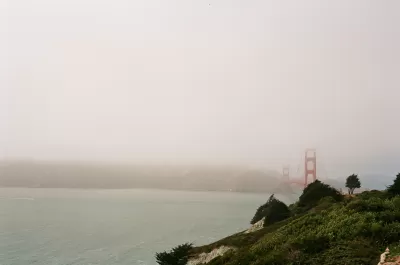
Nestled just south of the Golden Gate Bridge, a new section of parkland will connect the Presidio to the water. Nate Berg writes, "The Doyle Drive replacement, completed in 2015, is tucked inside concrete tunnels, the roofs of which will serve as green bridges linking the two sections of the Presidio that were separated in the 1930s." The cap park heals a physical divide that became very acute after the Presidio ceased its service as a U.S. Army base in 1994.
According to James Corner, of James Corner Field Operations, "'When you step out on the tunnel tops, you really get a 360-degree, geographical sort of centering vantage point where you can take in every landmark and every place that's significant in San Francisco and the bay.'" Corner's firm also designed New York's High Line, which has received significant attention and praise.
Covering freeways with parkland is an idea that has become increasingly popular nationwide. "In Dallas, for example, the 5.2‑acre Klyde Warren Park opened in 2012 on a platform over a sunken section of freeway. Los Angeles and Seattle are now considering similar freeway-cap parks."
FULL STORY: San Francisco’s Plan to Bury a Freeway

Pennsylvania Mall Conversion Bill Passes House
If passed, the bill would promote the adaptive reuse of defunct commercial buildings.

Coming Soon to Ohio: The Largest Agrivoltaic Farm in the US
The ambitious 6,000-acre project will combine an 800-watt solar farm with crop and livestock production.

World's Largest Wildlife Overpass In the Works in Los Angeles County
Caltrans will soon close half of the 101 Freeway in order to continue construction of the Wallis Annenberg Wildlife Crossing near Agoura Hills in Los Angeles County.

California Grid Runs on 100% Renewable Energy for Over 9 Hours
The state’s energy grid was entirely powered by clean energy for some portion of the day on 37 out of the last 45 days.

New Forecasting Tool Aims to Reduce Heat-Related Deaths
Two federal agencies launched a new, easy-to-use, color-coded heat warning system that combines meteorological and medical risk factors.

AI Traffic Management Comes to Dallas-Fort Worth
Several Texas cities are using an AI-powered platform called NoTraffic to help manage traffic signals to increase safety and improve traffic flow.
City of Costa Mesa
Licking County
Barrett Planning Group LLC
HUD's Office of Policy Development and Research
Mpact Transit + Community
HUD's Office of Policy Development and Research
Tufts University, Department of Urban and Environmental Policy & Planning
City of Universal City TX
ULI Northwest Arkansas
Urban Design for Planners 1: Software Tools
This six-course series explores essential urban design concepts using open source software and equips planners with the tools they need to participate fully in the urban design process.
Planning for Universal Design
Learn the tools for implementing Universal Design in planning regulations.