


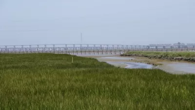
The San Francisco Bay Area serves as a case study, that applies in places like Louisiana as well, of how mud shortages compound the threats of sea level rise.

John Upton reports on the surprising panacea in the effort to adapt to rising sea levels in the marshlands of the San Francisco Bay Area. John Upton explains the problem:
Marshes capture mud from water to grow and sustain themselves. A worsening shortage of mud floating in San Francisco Bay and its waterways is contributing to erosion. It’s threatening plans to block flooding from sea level rise through the restoration of wetlands in the Bay Area, where homes and office buildings are packed into low-lying areas.
Meanwhile, scientists are quickly realizing the pressing need for these projects to be successfully implemented.
The article goes into great detail in describing the critical role of mud to habitat in the San Francisco Bay Area, though the problem is also rampant along the Louisiana coastline.
According to Upton, 42,000 acres of wetlands have been restored in the Bay Area since 1999, when Bay Area agencies released a plan to restore 100,000 acres of wetlands. More help could be on the way:
Voters in the nine Bay Area counties in June will consider imposing a new annual property tax [pdf] of $12 per parcel to reduce water pollution and help fund an acceleration of marsh restorations. Some of the funds could be spent addressing the sediment shortfall. The tax would raise about $25 million a year — “a fraction of what is needed,” a Contra Costa Times editorial noted last week.
FULL STORY: Mud Shortage Eroding California’s Climate Defenses
Bay Area's First Climate Adaptation Project Could Be a North Bay Highway
State Route 37 is a vital highway connecting four North Bay counties plagued by two unrelated problems: chronic flooding during high tides and traffic congestion. Fixing the problem will set a precedent for Bay Area climate adaptation.

Bay Area to Create Regional Plan for Sea-Level Rise
California wants the region to work together to deal with the impacts of climate change.
Parcel Tax Measure Would Fund Climate Adaptation in Bay Area by Restoring Wetlands
Next month, along with picking presidential, U.S. Senate and legislative candidates, and local ballot measures in a primary election, voters in the Bay Area will also determine the outcome of the first regionwide measure in Bay Area history.

Pennsylvania Mall Conversion Bill Passes House
If passed, the bill would promote the adaptive reuse of defunct commercial buildings.

Planning for Accessibility: Proximity is More Important than Mobility
Accessibility-based planning minimizes the distance that people must travel to reach desired services and activities. Measured this way, increased density can provide more total benefits than increased speeds.
Fair Housing Cannot Take a Back Seat to ‘Build, Baby, Build’
If we overlook fair housing principles in the plan to build US housing back better, we risk ending up right back where we started.

LA Metro Board Approves New 710 Freeway Plan
The newest plan for the 710 corridor claims it will not displace any residents.

Austin’s Proposed EV Charging Rules Regulate Station Locations, Size
City planners say the new rules would ensure an efficient distribution of charging infrastructure across the city and prevent an overconcentration in residential areas.

Making California State Parks More Climate-Resilient
A recently released report offers recommendations for keeping state parks healthy and robust, including acquiring additional land for conservation and recreation.
City of Costa Mesa
Licking County
Barrett Planning Group LLC
HUD's Office of Policy Development and Research
Mpact Transit + Community
HUD's Office of Policy Development and Research
Tufts University, Department of Urban and Environmental Policy & Planning
City of Universal City TX
ULI Northwest Arkansas
Urban Design for Planners 1: Software Tools
This six-course series explores essential urban design concepts using open source software and equips planners with the tools they need to participate fully in the urban design process.
Planning for Universal Design
Learn the tools for implementing Universal Design in planning regulations.