


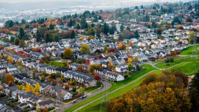
Census data shows that Seattle jumped Baltimore to become the country's tenth most densely populated city. Is Seattle on the cusp of a changing of the guard when it comes to density and population growth?

"Analysis of census data shows that Seattle — for the first time in its history — ranks among the top 10 most densely populated big cities in the U.S.," according to an article by Gene Balk.
"With 7,962 people per square mile in 2014, Seattle leapfrogged Baltimore into the No. 10 spot among the 50 most populous cities in the country. Seattle’s population density has increased by nearly 10 percent since the 2010 Census. And if current growth rates continue, we’ll bypass No. 9 Los Angeles within five years," adds Balk.
Balk places the new density figures in context of the city's ongoing development controversies, which erupted most publicly with the Housing Affordability and Livability Agenda (HALA) last year. Balk speaks extensively with Branden Born, associate professor of urban design and planning at the University of Washington, about the "D" word (density)—how the public perceives it and how they misperceive it. Born looks around the city and notes examples of density done right, as well as some example of how new development has changed the character of neighborhoods. Born predicts "a changing of the guard is under way when it comes to density and growth."
FULL STORY: Seattle among top 10 most densely populated big cities in the U.S. for first time ever
Beware of Energy Rankings for Cities
In a special "Energy for Tomorrow" report, The New York Times looks at "clean city rankings" of energy efficiency and land use. But ranking cities is no easy task—"winners on one list may appears as sinners on another."

Seattle Passes Downtown Zoning Reforms
The changes, part of the mayor’s Downtown Activation Plan, make way for more residential development in the city’s downtown core.
Seattle Works To Revise Comprehensive Plan
The city has developed five concepts for updating its comprehensive plan to increase density and reverse the legacy of exclusionary zoning.

Pennsylvania Mall Conversion Bill Passes House
If passed, the bill would promote the adaptive reuse of defunct commercial buildings.

Planning for Accessibility: Proximity is More Important than Mobility
Accessibility-based planning minimizes the distance that people must travel to reach desired services and activities. Measured this way, increased density can provide more total benefits than increased speeds.

World's Largest Wildlife Overpass In the Works in Los Angeles County
Caltrans will soon close half of the 101 Freeway in order to continue construction of the Wallis Annenberg Wildlife Crossing near Agoura Hills in Los Angeles County.

Eviction Looms for Low-Income Tenants as Rent Debt Rises
Nonprofit housing operators across the country face almost $10 billion in rent debt.

Brightline West Breaks Ground
The high-speed rail line will link Las Vegas and the Los Angeles area.

Colorado Bans No-Fault Evictions
In most cases, landlords must provide a just cause for evicting tenants.
City of Costa Mesa
Licking County
Barrett Planning Group LLC
HUD's Office of Policy Development and Research
Mpact Transit + Community
HUD's Office of Policy Development and Research
Tufts University, Department of Urban and Environmental Policy & Planning
City of Universal City TX
ULI Northwest Arkansas
Urban Design for Planners 1: Software Tools
This six-course series explores essential urban design concepts using open source software and equips planners with the tools they need to participate fully in the urban design process.
Planning for Universal Design
Learn the tools for implementing Universal Design in planning regulations.