


Created with input from historian Mark Footer, this tool overlays street views of modern Hong Kong with historical photos from the colonial era through the 20th century.
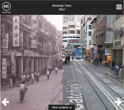
Here's an interesting urban visualization tool, this time featuring an Asian city. Historic Hong Kong interposes old photographs of notable locations onto how the streets look today using Google Street View. Users can hover over the historical photograph to switch between views.
According to outreach specialist Yolanda del Peso, the tool is optimized for mobile users: "If you are looking at it on mobile, or you shrink your browser down to mobile size, you can utilise a fader type functionality where you can literally swipe across to see the street now vs. 100 years ago - giving you what is almost a split screen view."
Planetizen has covered similar tools in the past, including an extensive effort to map wild Manhattan circa 1600.
FULL STORY: Historic Hong Kong
The Look and Feel of 'Inherently Urban'
Greek orators, current solution-based efforts, and 25 photographs remind us of the central role of human opportunity in the urban environment.
Interpreting the 'Timeless and Time-Bound' in Cities
In his latest essay on interpretation of the urban environment, Chuck Wolfe suggests that if we take away context clues cities become matrices -- with blank cells to complete -- where each of us personalizes how space meets time.

Tiny Parks Make Big Impact in Hong Kong
New pocket parks provide valuable opportunities for residents to play and gather in the territory's dense neighborhoods.

Pennsylvania Mall Conversion Bill Passes House
If passed, the bill would promote the adaptive reuse of defunct commercial buildings.

World's Largest Wildlife Overpass In the Works in Los Angeles County
Caltrans will soon close half of the 101 Freeway in order to continue construction of the Wallis Annenberg Wildlife Crossing near Agoura Hills in Los Angeles County.

U.S. Supreme Court: California's Impact Fees May Violate Takings Clause
A California property owner took El Dorado County to state court after paying a traffic impact fee he felt was exorbitant. He lost in trial court, appellate court, and the California Supreme Court denied review. Then the U.S. Supreme Court acted.

California Grid Runs on 100% Renewable Energy for Over 9 Hours
The state’s energy grid was entirely powered by clean energy for some portion of the day on 37 out of the last 45 days.

New Forecasting Tool Aims to Reduce Heat-Related Deaths
Two federal agencies launched a new, easy-to-use, color-coded heat warning system that combines meteorological and medical risk factors.

AI Traffic Management Comes to Dallas-Fort Worth
Several Texas cities are using an AI-powered platform called NoTraffic to help manage traffic signals to increase safety and improve traffic flow.
City of Costa Mesa
Licking County
Barrett Planning Group LLC
HUD's Office of Policy Development and Research
Mpact Transit + Community
HUD's Office of Policy Development and Research
Tufts University, Department of Urban and Environmental Policy & Planning
City of Universal City TX
ULI Northwest Arkansas
Urban Design for Planners 1: Software Tools
This six-course series explores essential urban design concepts using open source software and equips planners with the tools they need to participate fully in the urban design process.
Planning for Universal Design
Learn the tools for implementing Universal Design in planning regulations.