


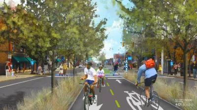
The city of Cleveland's first protected bike path has planning commission approval. The protected path is a component of the city's ambitious bike infrastructure plans.
Steven Litt reports that the Cleveland Planning Commission "unanimously approved conceptual plans for the Lorain Avenue Bikeway, modeled after the widely acclaimed Cultural Trail in Indianapolis."
"The $16 million Lorain Avenue project would transform 2.25 miles of the four-lane avenue from West 20th to West 65th Street into a multi-modal route with two lanes for vehicles, a lane for parking and bus stops, and a 10-foot strip separated from traffic for bikes."
If granted final approval, the protected path along Lorain Avenue would further the city's goals of doubling the mileage of city bike paths by 2017. The city also plans to add another 80 miles by 2019, according to Litt. The controversial Opportunity Corridor project also includes plans for a two-mile protected bike path along the route.
Litt notes the argument of complete streets and bike advocates that the city's road infrastructure was built for the larger population of the city in the 20th century, like other cities around the country.
Litt also describes the Cultural Trail in Indianapolis in more detail as an inspiration for the Lorain Avenue Bikeway.
FULL STORY: Lorain Avenue Bikeway concept gets a big boost from Cleveland planning commission (photos)
Two Steps Forward, One Step Back for Cleveland Cycle Track Plans
Advocates are thrilled that the city of Cleveland is seeking federal funding for a pair of ambitious cycle track plans—but one of the plans has been significantly watered down.

Cleveland's First Protected Bike Lanes Get $14 Million Boost
[Updated] The Northeast Ohio Areawide Coordinating Agency will provide the funding for two ambitious protected bike lanes in Cleveland.
Support for a Protected Bike Path Along Cleveland's 'Opportunity Corridor'
The unfolding saga of Cleveland's proposed Opportunity Corridor project has a new twist: community development organizations and bike advocates would like to add a protected bike path alongside the route.

Pennsylvania Mall Conversion Bill Passes House
If passed, the bill would promote the adaptive reuse of defunct commercial buildings.

World's Largest Wildlife Overpass In the Works in Los Angeles County
Caltrans will soon close half of the 101 Freeway in order to continue construction of the Wallis Annenberg Wildlife Crossing near Agoura Hills in Los Angeles County.

U.S. Supreme Court: California's Impact Fees May Violate Takings Clause
A California property owner took El Dorado County to state court after paying a traffic impact fee he felt was exorbitant. He lost in trial court, appellate court, and the California Supreme Court denied review. Then the U.S. Supreme Court acted.

California Grid Runs on 100% Renewable Energy for Over 9 Hours
The state’s energy grid was entirely powered by clean energy for some portion of the day on 37 out of the last 45 days.

New Forecasting Tool Aims to Reduce Heat-Related Deaths
Two federal agencies launched a new, easy-to-use, color-coded heat warning system that combines meteorological and medical risk factors.

AI Traffic Management Comes to Dallas-Fort Worth
Several Texas cities are using an AI-powered platform called NoTraffic to help manage traffic signals to increase safety and improve traffic flow.
City of Costa Mesa
Licking County
Barrett Planning Group LLC
HUD's Office of Policy Development and Research
Mpact Transit + Community
HUD's Office of Policy Development and Research
Tufts University, Department of Urban and Environmental Policy & Planning
City of Universal City TX
ULI Northwest Arkansas
Urban Design for Planners 1: Software Tools
This six-course series explores essential urban design concepts using open source software and equips planners with the tools they need to participate fully in the urban design process.
Planning for Universal Design
Learn the tools for implementing Universal Design in planning regulations.