


Local officials, planners, and other civic leaders have joined together to look at how the city can bring neighborhoods split by freeways back together again.

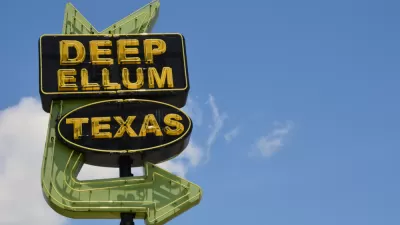
Brandon Formby reports in The Dallas Morning News on a new program lead by the Texas Department of Transportation in partnership with local planners and civic leaders. The goal of the new program called CityMAP is to produce a menu of option for how the city can begin to rebuild, tweak, or replace existing freeways surrounding downtown Dallas to overcome the freeway as a physical barrier that has separated the downtown core from surrounding neighborhoods. An existing example for innovative thinking is the city's Klyde Warren Park, built on a deck over a portion of the Woodall Rodgers Freeway, and opened in 2012. The park has become a popular spot for families and recreationists. However, future transit improvements, including the construction of a high-speed rail station and expansion of the rapid transit system through downtown, have also spurred new thinking for increasing connectivity throughout the city.
"The goal isn’t just to create more deck parks, though more could be in store. There are deeper hopes that updating major infrastructure in the urban core will restitch neighborhoods, spur developments with a dense mix of residences and job centers and give thousands of people the option to ditch their cars altogether."
Three meetings will be held in October and November to get public input on new ideas and potential solutions to create a more integrated downtown core, with the recognition that beyond just a destination, downtown has grown into a thriving live-work community.
FULL STORY: CityMAP planners envision future of downtown Dallas’ aging highways

Dallas City Council to Vote on Controversial Freeway Trenching Plan
A proposal to bury part of Interstate 345 in a 65-foot trench is the latest in a debate that has lasted more than ten years as the freeway reaches the end of its useful life.
Opinion: Hit the Brakes on Dallas Freeway Plan
A proposal to bury a Dallas freeway may not be the best way forward for the area’s residents.
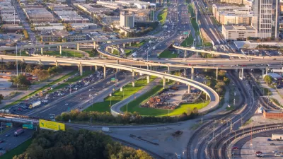
TxDOT Recommends a 10-Lane ‘Infrastructure Grave’ in Dallas
Rather than removing the freeway altogether, which the Texas Department of Transportation calls ‘unfeasible,’ the agency recommends burying the road in a billion-dollar, ten-lane trench through the city’s downtown.

Depopulation Patterns Get Weird
A recent ranking of “declining” cities heavily features some of the most expensive cities in the country — including New York City and a half-dozen in the San Francisco Bay Area.

California Exodus: Population Drops Below 39 Million
Never mind the 40 million that demographers predicted the Golden State would reach by 2018. The state's population dipped below 39 million to 38.965 million last July, according to Census data released in March, the lowest since 2015.

Chicago to Turn High-Rise Offices into Housing
Four commercial buildings in the Chicago Loop have been approved for redevelopment into housing in a bid to revitalize the city’s downtown post-pandemic.

How California Transit Agencies are Addressing Rider Harassment
Safety and harassment are commonly cited reasons passengers, particularly women and girls, avoid public transit.

Significant Investments Needed to Protect LA County Residents From Climate Hazards
A new study estimates that LA County must invest billions of dollars before 2040 to protect residents from extreme heat, increasing precipitation, worsening wildfires, rising sea levels, and climate-induced public health threats.

Federal Rule Raises Cost for Oil and Gas Extraction on Public Lands
An update to federal regulations raises minimum bonding to limit orphaned wells and ensure cleanup costs are covered — but it still may not be enough to mitigate the damages caused by oil and gas drilling.
City of Costa Mesa
Licking County
Barrett Planning Group LLC
HUD's Office of Policy Development and Research
Mpact Transit + Community
HUD's Office of Policy Development and Research
City of Universal City TX
ULI Northwest Arkansas
City of Laramie, Wyoming
Urban Design for Planners 1: Software Tools
This six-course series explores essential urban design concepts using open source software and equips planners with the tools they need to participate fully in the urban design process.
Planning for Universal Design
Learn the tools for implementing Universal Design in planning regulations.