


No, this is not a trick question. By definition, you'd think the answer is L.A., where the heat is generated, but it's actually San Bernardino, 56 miles to the east. Turns out that like ozone, heat is transported by the wind.

"Heat islands are created by a combination of heat-absorptive surfaces (such as dark pavement and roofing), heat-generating activities (such as engines and generators), and the absence of vegetation (which provides evaporative cooling)," according to the Urban Heat Island Index for California from the California Environmental Protection Agency (CalEPA).
Using the new index which tracks temperatures across the state, CalEPA found that "[t]he highest temperatures crop up east of downtown Los Angeles and are pushed into the inland valley by ocean breezes," writes Sanden Totten, science reporter for KPCC. [Listen here]
"In that way we found that the urban heat island effect in the L.A. area really mimicked the ozone pollution problem in L.A. where it moved east and settles against the hills," said Gina Solomon, Deputy Secretary for Science and Health with CalEPA.
She adds that the index, a result of 2012 legislation (AB 296, Chapter 667, Statutes of 2012), is a way of "quantifying the urban heat island effect." It "is designed so that cities can have a quantifiable goal for heat reduction," according to the webpage.
"We call it not an urban heat island but an urban heat archipelago because it's like a whole chain of urban heat islands that run into each other," Solomon said.
“The Urban Heat Island Index offers state and local governments a tool to help prioritize areas for programs that reduce heat in urban communities, such as urban greening projects and cooler roofs and pavements," notes the press release.
FULL STORY: LA area has highest urban heat island effect in California
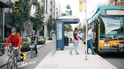
As Heat Waves Become More Common, Bus Shelters Are Needed to Keep Transit Riders Onboard
As climate change brings prolonged, intense heat waves to cities once associated with rain and cold weather will have to attend to the lack of shelter provided to bus and transit riders.

The Problem with Tree Planting Programs
Ambitious campaigns to plant trees in urban areas often don't take into account the complexities of growing and maintaining effective urban forests.

How Extreme Heat Threatens the Electrical Grid
Higher demand for electricity and lower capacity for production due to more intense heat waves are straining the power grid and causing concern for future energy production.

Pennsylvania Mall Conversion Bill Passes House
If passed, the bill would promote the adaptive reuse of defunct commercial buildings.

World's Largest Wildlife Overpass In the Works in Los Angeles County
Caltrans will soon close half of the 101 Freeway in order to continue construction of the Wallis Annenberg Wildlife Crossing near Agoura Hills in Los Angeles County.

U.S. Supreme Court: California's Impact Fees May Violate Takings Clause
A California property owner took El Dorado County to state court after paying a traffic impact fee he felt was exorbitant. He lost in trial court, appellate court, and the California Supreme Court denied review. Then the U.S. Supreme Court acted.

California Grid Runs on 100% Renewable Energy for Over 9 Hours
The state’s energy grid was entirely powered by clean energy for some portion of the day on 37 out of the last 45 days.

New Forecasting Tool Aims to Reduce Heat-Related Deaths
Two federal agencies launched a new, easy-to-use, color-coded heat warning system that combines meteorological and medical risk factors.

AI Traffic Management Comes to Dallas-Fort Worth
Several Texas cities are using an AI-powered platform called NoTraffic to help manage traffic signals to increase safety and improve traffic flow.
City of Costa Mesa
Licking County
Barrett Planning Group LLC
HUD's Office of Policy Development and Research
Mpact Transit + Community
HUD's Office of Policy Development and Research
Tufts University, Department of Urban and Environmental Policy & Planning
City of Universal City TX
ULI Northwest Arkansas
Urban Design for Planners 1: Software Tools
This six-course series explores essential urban design concepts using open source software and equips planners with the tools they need to participate fully in the urban design process.
Planning for Universal Design
Learn the tools for implementing Universal Design in planning regulations.