


Open data can be a powerful tool for illustrating the risks to public safety that will have to be overcome as more cities adopt Vision Zero initiatives.
"Montgomery County now publishes detailed traffic violation data, which goes online daily here," according to a post by Jacob Mason. "This data allows anyone to see where and when the police are issuing citations, and to whom." Mason used that data, for instance, to create a map of speeding violations covering June 1 through August 16. On the map, the size of the bubbles representing violations even correspond to how far over the speed limit the driver was traveling when cited.
With the map as an illustration, Mason argues for more and better open data projects by local governments. Mason pays specific attention to the Washington, D.C.'s region, which he says had made progress but can still improve.
FULL STORY: When governments make road data public, anyone can help make roads safer

Let’s End Traffic Stops
The technology to make traffic enforcement obsolete is becoming available. But in the U.S. willing to use it?
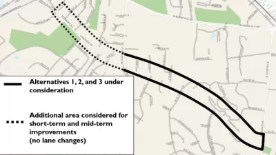
When it Comes to Road Diets, Evidence Doesn't Matter
Drivers are a powerful enough lobby to overcome all evidence of the need to redesign streets for safety. Examples from Maryland and Virginia provide the latest case studies in Vision Zero futility.
Speeding Camera Issues 6,000 Tickets in a Day—Is it Unfair?
After issuing 6,000 speeding tickets in one day, a speeding camera in Sheepshead Bay in New York City has already influenced driving habits. But some in the community are calling the location of the cameras a trap.

Pennsylvania Mall Conversion Bill Passes House
If passed, the bill would promote the adaptive reuse of defunct commercial buildings.

Coming Soon to Ohio: The Largest Agrivoltaic Farm in the US
The ambitious 6,000-acre project will combine an 800-watt solar farm with crop and livestock production.

World's Largest Wildlife Overpass In the Works in Los Angeles County
Caltrans will soon close half of the 101 Freeway in order to continue construction of the Wallis Annenberg Wildlife Crossing near Agoura Hills in Los Angeles County.

California Grid Runs on 100% Renewable Energy for Over 9 Hours
The state’s energy grid was entirely powered by clean energy for some portion of the day on 37 out of the last 45 days.

New Forecasting Tool Aims to Reduce Heat-Related Deaths
Two federal agencies launched a new, easy-to-use, color-coded heat warning system that combines meteorological and medical risk factors.

AI Traffic Management Comes to Dallas-Fort Worth
Several Texas cities are using an AI-powered platform called NoTraffic to help manage traffic signals to increase safety and improve traffic flow.
City of Costa Mesa
Licking County
Barrett Planning Group LLC
HUD's Office of Policy Development and Research
Mpact Transit + Community
HUD's Office of Policy Development and Research
Tufts University, Department of Urban and Environmental Policy & Planning
City of Universal City TX
ULI Northwest Arkansas
Urban Design for Planners 1: Software Tools
This six-course series explores essential urban design concepts using open source software and equips planners with the tools they need to participate fully in the urban design process.
Planning for Universal Design
Learn the tools for implementing Universal Design in planning regulations.