


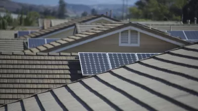
Currently in its early stages, Project Sunroof tracks how much sun every roof receives. Then it estimates the costs and savings if rooftop solar were installed. Right now, the tool only covers the Bay Area, Fresno, and Boston.

Google wants to make it easier for homeowners to think about going solar. A new map-based tool, Project Sunroof, lets users check whether their home (or any other structure within the coverage area) gets enough sunlight to warrant solar installation. Then it estimates costs and savings. In its current stage, the tool only covers the Bay Area, Fresno, and Boston.
Once you look up an address, "you can fine-tune the estimate to figure out whether solar panels on your roof make financial sense, by plugging in your monthly electric bill, choosing a financing option (leasing versus loans versus buying), and so forth."
Project Sunroof's estimates take local circumstances into account. "California, for instance, has high electricity prices, which means there are bigger potential savings from installing rooftop solar. The tool also factors in various regional policy incentives — like state tax incentives, local rebates, and what kind of net metering rules a state has [...]"
The article discusses how residents of multi-family dwellings can take advantage of community solar. "These are programs in which people who don't own suitable roofs can agree to 'subscribe' to electricity from a solar PV project elsewhere. They then pay a monthly charge that appears on their utility bill."
FULL STORY: Are solar panels right for you? Google's new mapping tool can help you decide
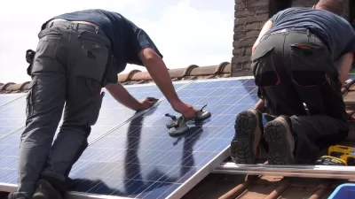
Mapping Rooftop Solar to Make It a Social Norm
Debuted in 2015, Google's Project Sunroof is designed make it easier for homeowners to go solar. Now the tool is harnessing peer pressure to "create a social norm" around solar.
California Could Drastically Cut Solar Incentives
Rooftop solar customers in California could face higher costs and reduced incentives if a proposed overhaul of the state's solar program is approved by the Public Utilities Commission.

Solar Canopies Provide a Solution for New York Roofs
A design fix helps Brooklyn brownstones go green.

Pennsylvania Mall Conversion Bill Passes House
If passed, the bill would promote the adaptive reuse of defunct commercial buildings.

World's Largest Wildlife Overpass In the Works in Los Angeles County
Caltrans will soon close half of the 101 Freeway in order to continue construction of the Wallis Annenberg Wildlife Crossing near Agoura Hills in Los Angeles County.

U.S. Supreme Court: California's Impact Fees May Violate Takings Clause
A California property owner took El Dorado County to state court after paying a traffic impact fee he felt was exorbitant. He lost in trial court, appellate court, and the California Supreme Court denied review. Then the U.S. Supreme Court acted.

California Grid Runs on 100% Renewable Energy for Over 9 Hours
The state’s energy grid was entirely powered by clean energy for some portion of the day on 37 out of the last 45 days.

New Forecasting Tool Aims to Reduce Heat-Related Deaths
Two federal agencies launched a new, easy-to-use, color-coded heat warning system that combines meteorological and medical risk factors.

AI Traffic Management Comes to Dallas-Fort Worth
Several Texas cities are using an AI-powered platform called NoTraffic to help manage traffic signals to increase safety and improve traffic flow.
City of Costa Mesa
Licking County
Barrett Planning Group LLC
HUD's Office of Policy Development and Research
Mpact Transit + Community
HUD's Office of Policy Development and Research
Tufts University, Department of Urban and Environmental Policy & Planning
City of Universal City TX
ULI Northwest Arkansas
Urban Design for Planners 1: Software Tools
This six-course series explores essential urban design concepts using open source software and equips planners with the tools they need to participate fully in the urban design process.
Planning for Universal Design
Learn the tools for implementing Universal Design in planning regulations.