


A study published in the Proceedings of the National Academy of Sciences finds evidence of the decline of sprawl as the dominant form of construction in the United States and attracted lots of media attention in the process.
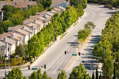
The study, "A century of sprawl in the United States," by Christopher Barrington-Leigh and Adam Millard, constructed a "long-run, high-resolution time series" of street-network sprawl in the United States to find that despite the lack of a coordinated policy effort, communities around the United States have moved beyond peak sprawl.
A trio of news outlets picked up the news yesterday, which indicates the interest captured by the idea of sprawl and its command over the American built environment.
Nathan Collins covered the story for Pacific Standard, focusing on the study's use of a term called "node degree" to measure sprawl. "To measure street connectivity, the pair used the concept of node degree, a term borrowed from network science that quantifies the number of paths in and and [sic] out of a point—in this case, the number of streets going in and out of an intersection. A four-way intersection has degree four, for example, while a T-intersection has degree three." According to the study's analysis, American streets began a decline in node degree from an average figure of 3.2 during the 1920s. The nadir came in the mid-1990s when the country's average node degree hit 2.6. A reversal in America's sprawl habit followed, pushing node degree back to 2.89 by 2012.
Coverage by Seth Borenstein for Phys.org focused on some of the areas controlling for sprawl, according to the study: "The five counties that Barrington-Leigh found to be controlling sprawl the most since the mid-1990s are Travis County, Texas; Mecklenburg County, North Carolina; Alachua County, Florida; Iredell County, North Carolina; and Franklin County, Ohio. He found the Austin region's new construction has cut sprawl by nearly one-quarter in that time." Borenstein also found a researcher at the University of Utah who questions the use of street connectivity as a measure of sprawl.
Finally, an article by Eric Jaffe for CityLab focuses on how the study changes the traditional timeline of the dominance of sprawl. According to Jaffe's interpretation, Barrington-Leigh and Millard-Ball show that "sprawl started to rise in the mid-1920s—indicated by a drop in average street node scores. The trend suggests that developers started to copy the early cul-de-sac planning that occurred in the likes of Radburn, New Jersey, in 1928. When the interstate system emerged, says Millard-Ball, it perpetuated a disconnect street trajectory many metro areas were already following."
FULL STORY: A century of sprawl in the United States

Cities Have Doubled in Size Globally in the Last 20 Years, Study Says
New research from China finds an incredible rate of urban expansion in North America and China.

The World's Streets Are Becoming Less Connected, Study Shows
The world is sprawling as it develops, according to ambitious new research.

Mapping the Collision Course of Sprawl and Biodiversity
The expansion of the built environment proceeds with little regard for the loss of biodiversity, and the planning field isn't doing enough to help.

Depopulation Patterns Get Weird
A recent ranking of “declining” cities heavily features some of the most expensive cities in the country — including New York City and a half-dozen in the San Francisco Bay Area.

California Exodus: Population Drops Below 39 Million
Never mind the 40 million that demographers predicted the Golden State would reach by 2018. The state's population dipped below 39 million to 38.965 million last July, according to Census data released in March, the lowest since 2015.

Chicago to Turn High-Rise Offices into Housing
Four commercial buildings in the Chicago Loop have been approved for redevelopment into housing in a bid to revitalize the city’s downtown post-pandemic.

Google Maps Introduces New Transit, EV Features
It will now be easier to find electric car charging stations and transit options.

Ohio Lawmakers Propose Incentivizing Housing Production
A proposed bill would take a carrot approach to stimulating housing production through a grant program that would reward cities that implement pro-housing policies.

Chicago Awarded $2M Reconnecting Communities Grant
Community advocates say the city’s plan may not do enough to reverse the negative impacts of a major expressway.
City of Costa Mesa
Licking County
Barrett Planning Group LLC
HUD's Office of Policy Development and Research
Mpact Transit + Community
HUD's Office of Policy Development and Research
City of Universal City TX
ULI Northwest Arkansas
Town of Zionsville
Urban Design for Planners 1: Software Tools
This six-course series explores essential urban design concepts using open source software and equips planners with the tools they need to participate fully in the urban design process.
Planning for Universal Design
Learn the tools for implementing Universal Design in planning regulations.