


Following a "Mayors Challenge" for bike safety by Transportation Secretary Anthony Foxx earlier this year, the U.S. Department of Transportation recently released a "Road Diets" report, providing a geographical diverse collection of case studies.
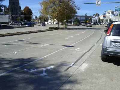
Josh Feit reports on the contents of a report by the U.S. Department of Transportation that presents case studies of road diets from around the country. Feit focuses on the three Seattle road diets (Feit prefers the term road safety design because "the process actually redesigns roads to carry more people not less thanks to typical changes such as adding bike lanes, sidewalks, bus hubs, and pedestrian islands"), which all received high marks from the U.S. DOT.
"Taking a close look at the Dexter 'right size,' the Nickerson safety redesign, and the Stone Way upgrade, U.S. DOT cheered SDOT’s success at using smart traffic math—going from four car lanes to two, adding buffered bike lanes and floating bus stops, and adding crosswalks, curb bulb outs, and pedestrian islands—to make roads more efficient and multimodal," writes Feit.
As for the remainder of the case studies in the "Road Diet" report [pdf], 24 are presented in total in the following locations as diverse as Genesee County in Michigan to Reston in Virginia to Santa Monica in California. More resources from the federal government regarding road safety design includes the Federal Highway Administration's Road Diets website.
FULL STORY: Ethics Commission DISLIKES Murray’s Response to Sawant; the Feds LOVE SDOT
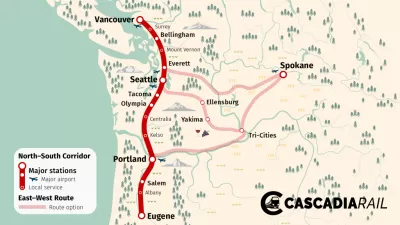
Cascadia High-Speed Rail Corridor Seeking Federal Funding
The state of Washington is hoping federal infrastructure funding can pay for $198 million of the $348 million necessary to plan the Cascadia High-Speed Rail project.

NJ v. U.S. DOT: Cordon Pricing in Manhattan
The State of New Jersey filed a federal lawsuit against the U.S. Department of Transportation on Friday to halt the Manhattan cordon pricing project approved in June by the FHWA, charging that they violated the National Environmental Protection Act.
National Mileage Fee Pilot Program Late to Launch
EV sales are increasing–good news for the environment but bad news for road funding, as they pay no fuel taxes. Fortunately, the bipartisan infrastructure law has $125 million earmarked to "demonstrate a national motor vehicle per-mile user fee."

Pennsylvania Mall Conversion Bill Passes House
If passed, the bill would promote the adaptive reuse of defunct commercial buildings.

World's Largest Wildlife Overpass In the Works in Los Angeles County
Caltrans will soon close half of the 101 Freeway in order to continue construction of the Wallis Annenberg Wildlife Crossing near Agoura Hills in Los Angeles County.

U.S. Supreme Court: California's Impact Fees May Violate Takings Clause
A California property owner took El Dorado County to state court after paying a traffic impact fee he felt was exorbitant. He lost in trial court, appellate court, and the California Supreme Court denied review. Then the U.S. Supreme Court acted.

California Grid Runs on 100% Renewable Energy for Over 9 Hours
The state’s energy grid was entirely powered by clean energy for some portion of the day on 37 out of the last 45 days.

New Forecasting Tool Aims to Reduce Heat-Related Deaths
Two federal agencies launched a new, easy-to-use, color-coded heat warning system that combines meteorological and medical risk factors.

AI Traffic Management Comes to Dallas-Fort Worth
Several Texas cities are using an AI-powered platform called NoTraffic to help manage traffic signals to increase safety and improve traffic flow.
City of Costa Mesa
Licking County
Barrett Planning Group LLC
HUD's Office of Policy Development and Research
Mpact Transit + Community
HUD's Office of Policy Development and Research
Tufts University, Department of Urban and Environmental Policy & Planning
City of Universal City TX
ULI Northwest Arkansas
Urban Design for Planners 1: Software Tools
This six-course series explores essential urban design concepts using open source software and equips planners with the tools they need to participate fully in the urban design process.
Planning for Universal Design
Learn the tools for implementing Universal Design in planning regulations.