


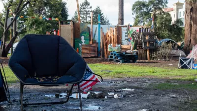
San Jose's attractive urban waterways, especially Coyote Creek, house over 1200 people living in about 66 illicit encampments, all without sanitation. It's clear that clean water and housing needs are connected. What that means is up for debate.
A glance at a terrain map (see http://goo.gl/maps/EXPPw) shows why San Jose shares in California's old tradition of creekside encampments by marginalized people, and why civic planners could have reasons to wish otherwise. Coyote Creek and the Guadalupe River (and, less extensively, Los Gatos Creek) run for miles through suburban and urban neighborhoods, broadening frequently into parks. The waterways are logical choices for hidden campsites. They are also a logical focus for civic efforts to build a denser, more prosperous urban core. (Encampments are a major issue at the city's redeveloped Guadalupe River Park.)
Coyote Creek, which has the most campers, is the most trash-blighted waterway in San Jose and probably the Bay Area. There are pressures for improvement from environmental groups, the state Fish and Wildlife agency, and the application of regional stormwater rules. In 2012 Save the Bay singled out Coyote Creek as possibly the worst of five "trash hot spots" it said were in violation of the Clean Water Act. (See http://www.savesfbay.org/bths-media-center.) The creek is choked with "trash dams" of plastic, styrofoam food packages, and other debris. The water, when it can be seen at all, is not to be touched without precautions. Reliable reports that a few steelhead trout frequent its waters are a tribute to the heroism of fish.
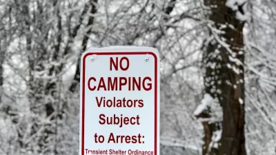
There are constant official efforts to remove encampments, but lacking other places to go, the campers come back. And as more other places in the city become unwelcoming to visibly homeless people, the waterside groups become increasingly dense. One may be the largest of its kind in the U.S.
It's clear that Silicon Valley's housing affordability crisis is linked to the troubled state of its urban waterways. And the double problem is too big for the city's current program of enforcement/cleanup sweeps supplemented by the Downtown Streets Team "work experience"/counseling program and a modestly funded plan to assist 200 of the campers with temporary housing vouchers and case management.
Something has to shift, and when it does shift, it needs to involve campers as participating, fully recognized members of the civic community, rather than finding new top-down ways to exclude or contain them. (See Christopher Herring's good paper about nationwide concerns on this issue.)
Everyone's stated long-term goal is for the people living outdoors to move indoors, to have their own conventional affordable homes in apartments or at least residential hotels. But what to do in the long meantime? One idea -- disfavored by city officials -- is to provide sanitation facilities temporarily to campers where they are now. Another is microhousing on the model of self-governing communities in Portland and Eugene. (See www.tentcityurbanism.com.)
Along Coyote Creek, an interesting conversation is beginning among poverty activists, city officials, and a group of neighbors who have serious credentials in water management and environmental activism.
The future of the campers, and of the waterways, is precarious at present. It's not clear what the local conversation, and the political and economic pressures around it, may allow to happen next.
FULL STORY: Hydraulics of homelessness: stormwater challenges are linked to encampments in San Jose
Opinion: Unhoused People Need Housing, Not Law Enforcement
The sharp increase in the unhoused population calls for urgent action, not criminalization.

An Affordable Housing Model for Indigenous Americans
Indigenous people make up a disproportionately high percentage of the unhoused population, but many programs designed to assist them don’t reach those most in need.
UC Berkeley Says Supportive Housing ‘Inseparable’ Part of People’s Park Project
The park remains closed to the public as a court weighs a decision on the university’s proposed housing development.

Pennsylvania Mall Conversion Bill Passes House
If passed, the bill would promote the adaptive reuse of defunct commercial buildings.

Planning for Accessibility: Proximity is More Important than Mobility
Accessibility-based planning minimizes the distance that people must travel to reach desired services and activities. Measured this way, increased density can provide more total benefits than increased speeds.

World's Largest Wildlife Overpass In the Works in Los Angeles County
Caltrans will soon close half of the 101 Freeway in order to continue construction of the Wallis Annenberg Wildlife Crossing near Agoura Hills in Los Angeles County.

Colorado Bans No-Fault Evictions
In most cases, landlords must provide a just cause for evicting tenants.

Alaska Village Becomes Test Case for Climate Change Relocation
The Yup’ik village of Newtok is the first Alaska community to begin a full-scale relocation necessitated by the impacts of climate change. Another 31 Alaska communities remain vulnerable.

Amtrak Takes Lead on Texas Central Rail
The high-speed rail project isn’t a done deal, but if it moves forward, trains could begin operating in 2030.
City of Costa Mesa
Licking County
Barrett Planning Group LLC
HUD's Office of Policy Development and Research
Mpact Transit + Community
HUD's Office of Policy Development and Research
Tufts University, Department of Urban and Environmental Policy & Planning
City of Universal City TX
ULI Northwest Arkansas
Urban Design for Planners 1: Software Tools
This six-course series explores essential urban design concepts using open source software and equips planners with the tools they need to participate fully in the urban design process.
Planning for Universal Design
Learn the tools for implementing Universal Design in planning regulations.