


Planners in Houston are working on street configurations in large swaths of the city. The plans reflect Mayor Annise Parker's recent executive order to embrace complete streets as well as a growing demand among residents for walkable, safe streets.
Dug Begley reports on an effort in Houston to send much of the city on a road diet. "…in a departure from what many consider the Houston model, the city is calling for reducing the space for cars and trucks. Plans for Dunlavy, along with a handful of other street segments between River Oaks, downtown and U.S. 59 and along the Washington Avenue corridor, will decrease driving room in favor of retaining trees and making parking, bicycling and walking easier."
"Most of the 2014 changes proposed are inside Loop 610, though a handful would create better connections to industrial areas in the eastern part of the city. Various changes are proposed in newly developed areas on the city's fringes as well."
The amendments to the city's transportation plan would appear in the 2014 major thoroughfare and freeway plan, according to Begley. The City Council is expected to vote on the proposed changes by September.
"What's significant, officials said, is the decision to reduce driving lanes in some spots. The traditional Houston method of improving a four-lane road - turning it into a five- or six-lane road - is falling out of favor in many neighborhoods, with residents reluctant to lose more private land to roads."
The article also includes a video of Houston Transportation Planning Group head Amar Mohite making the case for such changes.
FULL STORY: Street plans call for doing more with less driving room
Houston Mayor Pauses Complete Streets Projects
The move raises concerns among road safety advocates who point out that traffic deaths continue to rise.

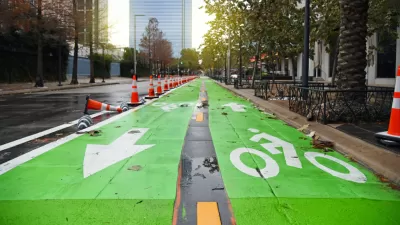
A Major Makeover for Houston Street
Bagby Street in Houston will soon have wider sidewalks and a new bike lane.
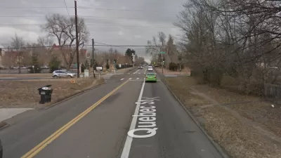
Plan for Expanded Road Inconsistent With Denver's Values
The idea of road improvement catering only to cars and congestion didn't pass muster on Quebec Street in Denver. A new plan for the heavily used, but narrow, corridor will prioritize pedestrians, safety, and transit.

Pennsylvania Mall Conversion Bill Passes House
If passed, the bill would promote the adaptive reuse of defunct commercial buildings.

Planning for Accessibility: Proximity is More Important than Mobility
Accessibility-based planning minimizes the distance that people must travel to reach desired services and activities. Measured this way, increased density can provide more total benefits than increased speeds.

World's Largest Wildlife Overpass In the Works in Los Angeles County
Caltrans will soon close half of the 101 Freeway in order to continue construction of the Wallis Annenberg Wildlife Crossing near Agoura Hills in Los Angeles County.

Eviction Looms for Low-Income Tenants as Rent Debt Rises
Nonprofit housing operators across the country face almost $10 billion in rent debt.

Brightline West Breaks Ground
The high-speed rail line will link Las Vegas and the Los Angeles area.

Colorado Bans No-Fault Evictions
In most cases, landlords must provide a just cause for evicting tenants.
City of Costa Mesa
Licking County
Barrett Planning Group LLC
HUD's Office of Policy Development and Research
Mpact Transit + Community
HUD's Office of Policy Development and Research
Tufts University, Department of Urban and Environmental Policy & Planning
City of Universal City TX
ULI Northwest Arkansas
Urban Design for Planners 1: Software Tools
This six-course series explores essential urban design concepts using open source software and equips planners with the tools they need to participate fully in the urban design process.
Planning for Universal Design
Learn the tools for implementing Universal Design in planning regulations.