


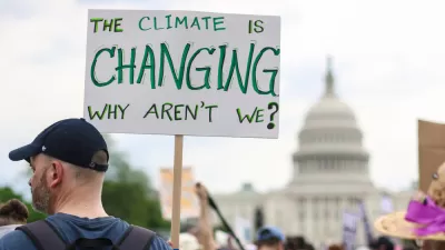
For the third time since 2000, the federal government has issued a National Climate Assessment, as mandated by Congress in 1990, to “understand, assess, predict, and respond" to climate change. The report was approved by President Obama on Tuesday.
"The report, the National Climate Assessment, was prepared by a large scientific panel overseen by the government. The report was unveiled at the White House, and President Obama planned to spend part of the day highlighting the findings in interviews with television weather forecasters around the country," writes Justin Gillis. Previous assessments were released in 2000 and 2009, as well as numerous intermittent ones, accessible here. A draft of this assessment was released last year and posted here.
The assessments were initiated under President George H. W. Bush in 1989 and "mandated by Congress in the Global Change Research Act (GCRA) of 1990 to 'assist the Nation and the world to understand, assess, predict, and respond to human-induced and natural processes of global change'.”
The report shows that impacts are "being felt in every corner of the United States" as opposed to being felt only in future years, as once thought. "If greenhouse gases like carbon dioxide and methane continue to escalate at a rapid pace, (the scientists) said, the warming could conceivably exceed 10 degrees by the end of this century," writes Gillis.
The administration hopes to use the report to shore up public support for the president’s climate policies as he attempts to put new regulations in place to limit emissions. A major political battle over the rules is expected this summer, with Republicans already accusing Mr. Obama of plotting a “war on coal.”
"However, scientists involved in the report said there had been no political interference in their work. In fact, they went beyond any language the president has used as they cataloged risk," adds Gillis.
While impacts may be inescapable throughout the U.S., that doesn't mean they are equally felt. "The impact is uneven in the United States. Some states are warming faster than others," writes Ben Schiller, staff writer for Co.Exist. Readers can click on any state in a map in the article to see the annual temperature increase since 1970.
The national assessments should not be confused with international reports on climate change prepared by the Intergovernmental Panel on Climate Change (IPCC), a U.N. panel.
FULL STORY: Climate Change Study Finds U.S. Is Already Widely Affected
Bi-Partisan Energy Efficiency Bill Stalls while Obama Pushes Initiative
A bi-partisan Senate bill to dramatically reduce carbon emissions by increasing energy efficiency got caught-up in Keystone XL pipeline politics, while President Barak Obama pursued his own energy efficiency agenda at a Walmart in Mtn. View, Calif.

Tracking Boston’s Emissions Reduction Progress
The Boston Foundation published the “Inaugural Boston Climate Progress Report” earlier this month. Other U.S. cities should follow their lead.
How Cities Can Curb Climate Change and Protect Vulnerable Residents
A new U.N. report urges cities to upgrade their infrastructure to bolster climate resilience and build more sustainable, climate-friendly places.

Depopulation Patterns Get Weird
A recent ranking of “declining” cities heavily features some of the most expensive cities in the country — including New York City and a half-dozen in the San Francisco Bay Area.

California Exodus: Population Drops Below 39 Million
Never mind the 40 million that demographers predicted the Golden State would reach by 2018. The state's population dipped below 39 million to 38.965 million last July, according to Census data released in March, the lowest since 2015.

Chicago to Turn High-Rise Offices into Housing
Four commercial buildings in the Chicago Loop have been approved for redevelopment into housing in a bid to revitalize the city’s downtown post-pandemic.

Google Maps Introduces New Transit, EV Features
It will now be easier to find electric car charging stations and transit options.

Ohio Lawmakers Propose Incentivizing Housing Production
A proposed bill would take a carrot approach to stimulating housing production through a grant program that would reward cities that implement pro-housing policies.

Chicago Awarded $2M Reconnecting Communities Grant
Community advocates say the city’s plan may not do enough to reverse the negative impacts of a major expressway.
City of Costa Mesa
Licking County
Barrett Planning Group LLC
HUD's Office of Policy Development and Research
Mpact Transit + Community
HUD's Office of Policy Development and Research
City of Universal City TX
ULI Northwest Arkansas
Town of Zionsville
Urban Design for Planners 1: Software Tools
This six-course series explores essential urban design concepts using open source software and equips planners with the tools they need to participate fully in the urban design process.
Planning for Universal Design
Learn the tools for implementing Universal Design in planning regulations.