


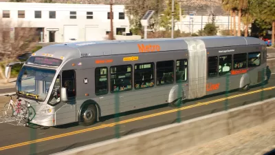
For anyone who's tried to commute between the San Fernando Valley and L.A.'s Westside during rush hour, it's clear the existing options just don't work. LA County is now considering six options - from BRT to rail tunnels - to help ease congestion.
Although Los Angeles is currently spending more than $1 billion to widen the 405 Freeway by one carpool lane northbound through the Sepulveda Pass, it's clear that more creative solutions will be required to dramatically improve the commute between the Westside and the Valley. Eric Jaffe looks at six options [PDF] that the Los Angeles County Metropolitan Transportation Authority (Metro) presented Valley residents with last week.
The most modest option would stripe 8.5 miles of the 405 for rapid bus use during peak hours at a cost of $162 million. According to Jaffe, "[t]he project is very cost-efficient and creates a minimal environmental impact, but Metro officials worry it doesn't provide the reliable, long-term transit option the corridor needs."
The most outlandish option would be build 21-mile-long highway and transit tunnels from the Valley to Los Angeles International Airport at an estimated cost of $30-38 billion. "This 'ultimate build-out'," says Jaffe, "would certainly require a private partnership, but suitors are out there; at least six companies have already reached out to Metro with an interest in building a tunnel for the corridor."
"For now," writes "Metro has $1 billion allotted for the Sepulveda Pass Corridor project, thanks to a half-percent sales tax that voters approved in 2008. That money, however, would not be available until 2039."
FULL STORY: 6 Ideas for L.A.'s Next Great Transit Project

L.A. Metro Report Examines How Women Travel
Findings from a new study about the mobility needs and concerns of women in Los Angeles will inform future initiatives and planning.
Thinking Outside of the Transit Box in L.A.
Metro is analyzing new geolocational data to look beyond conventional understandings of travel behavior.
Why Replace Successful BRT With Rail?
The Orange Line, a bus rapid transit line running through Los Angeles' San Fernando Valley, has been a success. To those calling for an expensive conversion to rail, several experts say, why bother?

Pennsylvania Mall Conversion Bill Passes House
If passed, the bill would promote the adaptive reuse of defunct commercial buildings.

Planning for Accessibility: Proximity is More Important than Mobility
Accessibility-based planning minimizes the distance that people must travel to reach desired services and activities. Measured this way, increased density can provide more total benefits than increased speeds.

World's Largest Wildlife Overpass In the Works in Los Angeles County
Caltrans will soon close half of the 101 Freeway in order to continue construction of the Wallis Annenberg Wildlife Crossing near Agoura Hills in Los Angeles County.

Eviction Looms for Low-Income Tenants as Rent Debt Rises
Nonprofit housing operators across the country face almost $10 billion in rent debt.

Brightline West Breaks Ground
The high-speed rail line will link Las Vegas and the Los Angeles area.

Colorado Bans No-Fault Evictions
In most cases, landlords must provide a just cause for evicting tenants.
City of Costa Mesa
Licking County
Barrett Planning Group LLC
HUD's Office of Policy Development and Research
Mpact Transit + Community
HUD's Office of Policy Development and Research
Tufts University, Department of Urban and Environmental Policy & Planning
City of Universal City TX
ULI Northwest Arkansas
Urban Design for Planners 1: Software Tools
This six-course series explores essential urban design concepts using open source software and equips planners with the tools they need to participate fully in the urban design process.
Planning for Universal Design
Learn the tools for implementing Universal Design in planning regulations.