


Cassim Shepard and Varick Shute respond to an exhortation by Governor Cuomo to "build [the New York City area] back smarter" in the aftermath of Superstorm Sandy, and in the face of changing weather patterns, with some ideas on what that will entail.
There isn't one single solution to building a New York metropolitan area more able to withstand the "new reality" of rising seas and extreme weather incidents that threaten the city, argue Shepard and Shute, but rather a range of tactics across multiple scales that can make the area more responsive and resilient.
"The kind of coordination we have seen between federal, state, and local officials over the past few days points both to pathways and to pitfalls on the road towards multi-scalar collaboration. Financial, political, and practical collaboration will be vital to creating an infrastructure commensurate with the challenges ahead. The investments necessary won't come top-down from the federal government in our current political climate. Nor can we rely exclusively on the DIY, bottom-up efforts of community groups and individual citizens to build the infrastructure of the future."
"Both national leadership and community stewardship will be necessary, mediated by the policies, investments, and interventions of states and cities. To 'build it back smarter,' as Governor Cuomo has called for, will require a shift in understanding what infrastructure means, how it performs, and how – when it's well designed, resilient, and responsive – its public benefits extend outwards across multiple and nested scales of citizenship, from community, to state, to nation, to planet."
FULL STORY: From the Editors: Build It Back Smarter
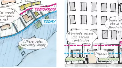
Proposed Citywide Rezoning Would Layer Resilience in New York City
With 520 miles of coastline, New York City is ready to implement the lessons of Hurricane Sandy in the zoning code for the entire city.
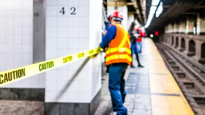
Why New York City's Flooding Its Own Subway Entrances
MTA reassured disoriented New Yorkers that it's flooding subway entrances on purpose, to test barriers that it hopes will guard the system against another Sandy.

Connecticut Shoreline Rail Vulnerable to Floods
Long stretches of Connecticut's "lifeblood" shoreline rail line lie in the path of rising seas and future floods. While moving the tracks further inland is prohibitively expensive, a resilience plan is still needed.

Pennsylvania Mall Conversion Bill Passes House
If passed, the bill would promote the adaptive reuse of defunct commercial buildings.

Planning for Accessibility: Proximity is More Important than Mobility
Accessibility-based planning minimizes the distance that people must travel to reach desired services and activities. Measured this way, increased density can provide more total benefits than increased speeds.

World's Largest Wildlife Overpass In the Works in Los Angeles County
Caltrans will soon close half of the 101 Freeway in order to continue construction of the Wallis Annenberg Wildlife Crossing near Agoura Hills in Los Angeles County.

Eviction Looms for Low-Income Tenants as Rent Debt Rises
Nonprofit housing operators across the country face almost $10 billion in rent debt.

Brightline West Breaks Ground
The high-speed rail line will link Las Vegas and the Los Angeles area.

Colorado Bans No-Fault Evictions
In most cases, landlords must provide a just cause for evicting tenants.
City of Costa Mesa
Licking County
Barrett Planning Group LLC
HUD's Office of Policy Development and Research
Mpact Transit + Community
HUD's Office of Policy Development and Research
Tufts University, Department of Urban and Environmental Policy & Planning
City of Universal City TX
ULI Northwest Arkansas
Urban Design for Planners 1: Software Tools
This six-course series explores essential urban design concepts using open source software and equips planners with the tools they need to participate fully in the urban design process.
Planning for Universal Design
Learn the tools for implementing Universal Design in planning regulations.