


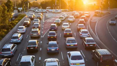
Zak Stone spotlights a new app being tested in Germany that can predict and prevent traffic jams, and promises to reduce CO2 emissions in the process.
The new app for Windows Phones, called Greenway,
works by plugging "its users' locations,
destinations, and speeds into an algorithm to figure out where and when
traffic jams are likely to occur. Then, it provides a route to steer
cars away from those roads. The route is called, appopriately [sic], the
"Greenway," and it's optimized for traffic, time, and the amount of gas
used based on data about where other drivers are headed at the same
time."
According to Stone, "One of the more interesting parts of the app is the business model. The
app is free to use, but users who select the Greenway route will pay a
small fee for the insider information: five percent of the cost of fuel
they'll save by taking the Greenway, but never more than 30 cents per
route. If it takes users longer than it should to get to their
desintation [sic], the information is on the house."
There is one catch, however: "The founders estimate that for the app to truly be effective, they'd
need to get at least 10 percent of a city's drivers on board."
FULL STORY: An App that Sees and Prevents Future Traffic Jams

Planning for Congestion Relief
The third and final installment of Planetizen's examination of the role of the planning profession in both perpetuating and solving traffic congestion.
How Planning Fails to Solve Congestion
Solutions for congestion are never as simple and easy as armchair planners and engineers would like you to believe—especially those who suggest that congestion can be solved by forever building more roadway capacity.

Planning and the Complicated Causes and Effects of Congestion
What do planners know about congestion, and what can they do about it? Explanations and solutions are less obvious than they seem (part one of a three-part series).

Depopulation Patterns Get Weird
A recent ranking of “declining” cities heavily features some of the most expensive cities in the country — including New York City and a half-dozen in the San Francisco Bay Area.

California Exodus: Population Drops Below 39 Million
Never mind the 40 million that demographers predicted the Golden State would reach by 2018. The state's population dipped below 39 million to 38.965 million last July, according to Census data released in March, the lowest since 2015.

Chicago to Turn High-Rise Offices into Housing
Four commercial buildings in the Chicago Loop have been approved for redevelopment into housing in a bid to revitalize the city’s downtown post-pandemic.

Median Home Prices Top $1 Million in Over 200 California Towns
Towns once known for their affordability are seeing sharply rising home prices.

LA County Receives Reconnecting Communities Grants
Seven grant awards totaling $162 million will be used for planning, capital projects, and regional partnerships to reduce environmental harm and improve access in disadvantaged communities.

Seine Pollution Could Hinder Olympic Swim Events
Events like the triathlon could be impacted if tests continue to reveal high levels of dangerous bacteria in Paris’ famous river.
Licking County
Barrett Planning Group LLC
City of Cleburne
HUD's Office of Policy Development and Research
Mpact Transit + Community
HUD's Office of Policy Development and Research
City of Universal City TX
ULI Northwest Arkansas
City of Laramie, Wyoming
Urban Design for Planners 1: Software Tools
This six-course series explores essential urban design concepts using open source software and equips planners with the tools they need to participate fully in the urban design process.
Planning for Universal Design
Learn the tools for implementing Universal Design in planning regulations.