


Interactive maps of Manhattan from 1865 and 2008 are overlayed in this piece from The New York Moon that discusses the history of the island's waterways.
"Beneath New York's lattices of concrete, iron and landfill lie dozens of organic waterways. Using data from an 1865 sanitation map and contemporary satellite photographs, this projection depicts Manhattan as a vascular organ, whose obscure operation has had a powerful bearing on the fate of the city."
"Created for the department of sanitation, the map was a reminder that natural water systems, entombed beneath modern accumulations, hidden from view, could still have monumental effects on the functioning of city life. Indeed, structural engineers and city planners continue to consult the Viele map as the authoritative survey of Manhattan's water systems."
"In overlaying this map with a recent projection based on satellite photographs, this map seeks to continue to probe the relationship between the terrain we walk and the watery ateries below."
Thanks to BLDGBLOG
FULL STORY: Water Systems of Manhattan
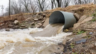
Southern Water Infrastructure at Risk From Climate Impacts
A water main breaks somewhere in the United States every two minutes, according to an estimate from the American Society of Civil Engineers.

California Water Plan Readies State for Climate-Impacted Future
A wet winter will replenish the state’s snowpack and reservoirs, but could also increase flooding and wildfire risk in some areas.

Fossil Fuel-Based Artificial Turf Raises Concerns
Cities and states are rolling back support for artificial turf, which can leach chemicals and microplastics into groundwater.

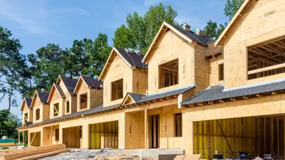
Pennsylvania Mall Conversion Bill Passes House
If passed, the bill would promote the adaptive reuse of defunct commercial buildings.

Planning for Accessibility: Proximity is More Important than Mobility
Accessibility-based planning minimizes the distance that people must travel to reach desired services and activities. Measured this way, increased density can provide more total benefits than increased speeds.
Fair Housing Cannot Take a Back Seat to ‘Build, Baby, Build’
If we overlook fair housing principles in the plan to build US housing back better, we risk ending up right back where we started.

LA Metro Board Approves New 710 Freeway Plan
The newest plan for the 710 corridor claims it will not displace any residents.

Austin’s Proposed EV Charging Rules Regulate Station Locations, Size
City planners say the new rules would ensure an efficient distribution of charging infrastructure across the city and prevent an overconcentration in residential areas.

Making California State Parks More Climate-Resilient
A recently released report offers recommendations for keeping state parks healthy and robust, including acquiring additional land for conservation and recreation.
City of Costa Mesa
Licking County
Barrett Planning Group LLC
HUD's Office of Policy Development and Research
Mpact Transit + Community
HUD's Office of Policy Development and Research
Tufts University, Department of Urban and Environmental Policy & Planning
City of Universal City TX
ULI Northwest Arkansas
Urban Design for Planners 1: Software Tools
This six-course series explores essential urban design concepts using open source software and equips planners with the tools they need to participate fully in the urban design process.
Planning for Universal Design
Learn the tools for implementing Universal Design in planning regulations.