


That's how developers at Google describe the release of Google Earth for the iPhone. Boing Boing's Joel Johnson wonders why it wasn't released for Android first.
"With just a swipe of your finger you can fly from Peoria to Paris to Papua New Guinea, or anywhere in between. It may be small, but it brings all the power of Google Earth to the palm of your hand, including all of the same global imagery and 3D terrain. You can even browse any of our 8 million Panoramio photos or read Wikipedia articles.
With Google Earth for iPhone, you can:
• Tilt your iPhone to adjust your view to see mountainous terrain
• View the Panoramio layer and browse the millions of geo-located photos from around the world
• View geo-located Wikipedia articles
• Use the 'Location' feature to fly to your current location
• Search for cities, places and business around the globe with Google Local Search"
From Boing Boing:
"I mean, I get it: Google is a big company. There are lots of product teams. Those teams probably have a lot of autonomy. Google is fine making software for all platforms, not just its own, since their customers use a variety of platforms.
But we're not talking about Gmail here. We're talking about a stunning bit of entertainment software that would set Android phones apart from their competition. And then Google Mobile distributes it for iPhone first?"
Thanks to gadgets.boingboing.net
FULL STORY: Introducing Google Earth for iPhone

Visualizing Worst-Case Scenario Sea Level Rise on the Texas Coast
Much of the state political leadership in Texas has been slow to accept the existence of climate change, much less the role of the state's economy, land use, and infrastructure planning in exacerbating the crisis. Maybe this will help wake them up?
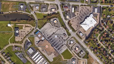
Retail Parking: A View from Google Earth
Google Earth can be a useful tool for understanding how parking is being used in your community and to identify where over- or under-utilization occurs.
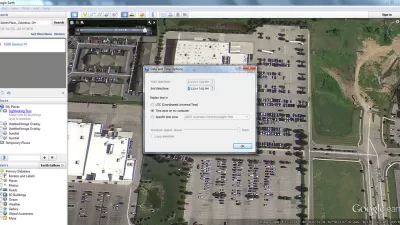
Using Google Earth to Understand Parking Utilization
As planners we use maps on a daily basis. This article shares how to find the date and time that a Google Earth image was taken, which can be helpful in undertaking site analysis and understanding parking utilization.

Pennsylvania Mall Conversion Bill Passes House
If passed, the bill would promote the adaptive reuse of defunct commercial buildings.

Planning for Accessibility: Proximity is More Important than Mobility
Accessibility-based planning minimizes the distance that people must travel to reach desired services and activities. Measured this way, increased density can provide more total benefits than increased speeds.

World's Largest Wildlife Overpass In the Works in Los Angeles County
Caltrans will soon close half of the 101 Freeway in order to continue construction of the Wallis Annenberg Wildlife Crossing near Agoura Hills in Los Angeles County.

New York Passes Housing Package Focused on New Development and Adaptive Reuse
The FY 2025 budget includes a new tax incentive, funding for affordable housing on state land, and support for adaptive reuse and ADUs.

LA Metro Board Approves New 710 Freeway Plan
The newest plan for the 710 corridor claims it will not displace any residents.

Austin’s Proposed EV Charging Rules Regulate Station Locations, Size
City planners say the new rules would ensure an efficient distribution of charging infrastructure across the city and prevent an overconcentration in residential areas.
City of Costa Mesa
Licking County
Barrett Planning Group LLC
HUD's Office of Policy Development and Research
Mpact Transit + Community
HUD's Office of Policy Development and Research
Tufts University, Department of Urban and Environmental Policy & Planning
City of Universal City TX
ULI Northwest Arkansas
Urban Design for Planners 1: Software Tools
This six-course series explores essential urban design concepts using open source software and equips planners with the tools they need to participate fully in the urban design process.
Planning for Universal Design
Learn the tools for implementing Universal Design in planning regulations.