


Chris Turner looks at successful car-free pedestrianization and bicycle planning in Copenhagen and Melbourne and wonders why Canada's sprawling, frigid cities can't adopt these ideas as well.
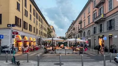
"If the pedestrian revival has a birthplace, it is [Copenhagen]. Considered a dull provincial burg in the 1950s, the cozy Danish capital now routinely tops international quality-of-life rankings - the ultra-hip current affairs journal Monocle recently declared it the world's most livable city. This newfound prominence rests largely on Copenhagen's inviting city centre, which is latticed with a half-dozen pedestrian-only promenades and a dozen car-free squares, stitched to the rest of the city by one of the world's more extensive networks of bicycle paths.
At the height of summer, a quarter-million people stroll Copenhagen's downtown streets each day, and 36 per cent of residents cycle to work, with the help of more than 300 kilometres of dedicated bike lanes and guided in congested areas by bike-only traffic lights...Most days the Strøget - the city's high street and Europe's longest pedestrian thoroughfare - is a forest of marching feet. Café seats encircle every downtown square, many of them draped on cool days in blankets for public use, with more sidewalk cafes crowding the narrowest back lanes.
The challenge [of pedestrianization and bicycle planning] may seem even greater for Canadian municipalities ...[but] Copenhagen has become a global leader in bicycle commuting despite a winter nearly as cold as that in most Canadian cities and much drearier."
FULL STORY: A Step in the Right Direction

Where Urban Design Is Headed in 2024
A forecast of likely trends in urban design and architecture.

Considering Mindfulness as an Urban Planner's Tool
A recent blog post in Substack considers the appropriation of mindfulness to urban observation and, implicitly, urban planning today.
Did the Pandemic Spur Radical Urban Change?
The Covid era highlighted social inequities and prompted new paradigms for urbanism and mobility. Will they stick around?

Pennsylvania Mall Conversion Bill Passes House
If passed, the bill would promote the adaptive reuse of defunct commercial buildings.

Planning for Accessibility: Proximity is More Important than Mobility
Accessibility-based planning minimizes the distance that people must travel to reach desired services and activities. Measured this way, increased density can provide more total benefits than increased speeds.

World's Largest Wildlife Overpass In the Works in Los Angeles County
Caltrans will soon close half of the 101 Freeway in order to continue construction of the Wallis Annenberg Wildlife Crossing near Agoura Hills in Los Angeles County.

Eviction Looms for Low-Income Tenants as Rent Debt Rises
Nonprofit housing operators across the country face almost $10 billion in rent debt.

Brightline West Breaks Ground
The high-speed rail line will link Las Vegas and the Los Angeles area.

Colorado Bans No-Fault Evictions
In most cases, landlords must provide a just cause for evicting tenants.
City of Costa Mesa
Licking County
Barrett Planning Group LLC
HUD's Office of Policy Development and Research
Mpact Transit + Community
HUD's Office of Policy Development and Research
Tufts University, Department of Urban and Environmental Policy & Planning
City of Universal City TX
ULI Northwest Arkansas
Urban Design for Planners 1: Software Tools
This six-course series explores essential urban design concepts using open source software and equips planners with the tools they need to participate fully in the urban design process.
Planning for Universal Design
Learn the tools for implementing Universal Design in planning regulations.