


This slideshow form Popular Science takes a step-by-step look at how to detect and uncover ancient buried settlements from satellite imagery.
"Lots of people live in Egypt. They always have. So how do you find ancient ruins when modern humans live and farm the land? Sarah Parcak of the University of Alabama at Birmingham uses images from a hyperspectral satellite, which has cameras that take pictures in various wavelengths. She sorts the data to reveal the high concentrations of organic matter and phosphorus content that mark ancient Egyptian house mounds. Then she gets a closer look and starts to dig."
FULL STORY: From Space to Shovel
First Cities: Planning Lessons for the 21st Century
A new book about urban planning in the deep human past explores principles, strategies, and lessons relevant for today.
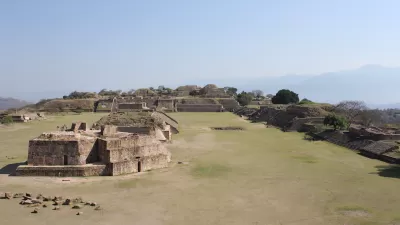
Amazonian Ruins Reveal Ancient ‘Garden Urbanism’
An archaeological site shows evidence of a unique layout of dense residential buildings interspersed with a network of roads and farmland.

Lessons for Software UX From Ancient City Planners
Cities have been designed for user experience (UX) for millennia, and contemporary UX designers have plenty to learn from planners, according to a recent article in Fast Company.

Pennsylvania Mall Conversion Bill Passes House
If passed, the bill would promote the adaptive reuse of defunct commercial buildings.

World's Largest Wildlife Overpass In the Works in Los Angeles County
Caltrans will soon close half of the 101 Freeway in order to continue construction of the Wallis Annenberg Wildlife Crossing near Agoura Hills in Los Angeles County.

Coming Soon to Ohio: The Largest Agrivoltaic Farm in the US
The ambitious 6,000-acre project will combine an 800-watt solar farm with crop and livestock production.

California Grid Runs on 100% Renewable Energy for Over 9 Hours
The state’s energy grid was entirely powered by clean energy for some portion of the day on 37 out of the last 45 days.

New Forecasting Tool Aims to Reduce Heat-Related Deaths
Two federal agencies launched a new, easy-to-use, color-coded heat warning system that combines meteorological and medical risk factors.

AI Traffic Management Comes to Dallas-Fort Worth
Several Texas cities are using an AI-powered platform called NoTraffic to help manage traffic signals to increase safety and improve traffic flow.
City of Costa Mesa
Licking County
Barrett Planning Group LLC
HUD's Office of Policy Development and Research
Mpact Transit + Community
HUD's Office of Policy Development and Research
Tufts University, Department of Urban and Environmental Policy & Planning
City of Universal City TX
ULI Northwest Arkansas
Urban Design for Planners 1: Software Tools
This six-course series explores essential urban design concepts using open source software and equips planners with the tools they need to participate fully in the urban design process.
Planning for Universal Design
Learn the tools for implementing Universal Design in planning regulations.