


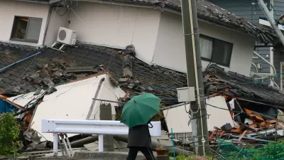
New earthquake hazard maps from the U.S. Geological Survey show increased earthquake risk areas beyond typical hotspots like California. Geologists say planners and local officials should react to the maps by updating building codes.
"The maps by the U.S. Geological Survey (USGS) reflect the discovery of more earthquake faults in California, a new 7.4-magnitude-quake risk in Utah, as well as more ways to rock the Midwest, South Carolina and the Pacific Northwest than you can shake a stick at."
"Unlike last week's forecast of possible ruptures along faults in California, the National Seismic Hazard Maps calculate the likely intensity of shaking at any given location -- caused by any regional fault giving way -- over a period of 50 years."
"As a result, the new maps are vital for updating local building codes and a direct response to the old geologist truism: Earthquakes don't kill people, buildings kill people."
FULL STORY: Shaky U.S. Grounds Revealed in New Maps
When the Earth Turns to Liquid
A 7.5 magnitude earthquake struck the Indonesian island of Sulawesi on Sept. 25, followed by a massive tsunami. Soil liquefaction caused by the tremor resulted in 1,700 homes being "swallowed" as the soil shifted. Deaths exceeded 1,400 on Oct. 3.

Bay Area Not Prepared for Next Big One
As the death toll from Mexico's 7.1 magnitude earthquake on Sept. 19 climbs above 300, the San Francisco Chronicle investigates how well prepared the Bay Area is for an earthquake of comparable magnitude. Not very well.
Mexico City Earthquake Should Raise Questions About Building Safety
The epicenter of Tuesday's quake was in the state of Puebla, 80 miles southeast of Mexico City. Soft soil and unreinforced buildings magnified the damage. The quake comes two weeks after an 8.1 quake struck off the coast of the state of Oaxaca.

Pennsylvania Mall Conversion Bill Passes House
If passed, the bill would promote the adaptive reuse of defunct commercial buildings.

Planning for Accessibility: Proximity is More Important than Mobility
Accessibility-based planning minimizes the distance that people must travel to reach desired services and activities. Measured this way, increased density can provide more total benefits than increased speeds.
Fair Housing Cannot Take a Back Seat to ‘Build, Baby, Build’
If we overlook fair housing principles in the plan to build US housing back better, we risk ending up right back where we started.

LA Metro Board Approves New 710 Freeway Plan
The newest plan for the 710 corridor claims it will not displace any residents.

Austin’s Proposed EV Charging Rules Regulate Station Locations, Size
City planners say the new rules would ensure an efficient distribution of charging infrastructure across the city and prevent an overconcentration in residential areas.

Making California State Parks More Climate-Resilient
A recently released report offers recommendations for keeping state parks healthy and robust, including acquiring additional land for conservation and recreation.
City of Costa Mesa
Licking County
Barrett Planning Group LLC
HUD's Office of Policy Development and Research
Mpact Transit + Community
HUD's Office of Policy Development and Research
Tufts University, Department of Urban and Environmental Policy & Planning
City of Universal City TX
ULI Northwest Arkansas
Urban Design for Planners 1: Software Tools
This six-course series explores essential urban design concepts using open source software and equips planners with the tools they need to participate fully in the urban design process.
Planning for Universal Design
Learn the tools for implementing Universal Design in planning regulations.