Writer–on-the-Range Alan Kesselheim describes the most hazardous activity in Montana -- driving, with a particular focus on Hwy 191 through Gallatin Canyon. Every western state has a similar, hazardous route.
"The Gallatin Canyon between Bozeman and Big Sky, Mont. is the second-busiest commuting corridor in the state, and the most dangerous. Between 5,500 and 7,500 drivers navigate the perilous gantlet of Highway 191 daily, on their way to work at booming construction sites, the popular Yellowstone National Park, and crowd-pleasing ski resorts."
"For these thousands of drivers and their passengers, it may be the most dangerous thing they ever do, and yet they take it on routinely enough that it becomes mundane. For all of us, unless we live in an active war zone, driving is statistically chancier than anything else in our lives. We may fixate on terrorists and nasty encounters with bears or mountain lions, but for true fear and loathing, nothing trumps time behind the wheel."
"Since 1996 there have been 21 deaths and 374 injuries along this one stretch of road. White crosses bloom on every curve. In a recent, and typical, three-year period there were 367 reported collisions between vehicles and wildlife. Who knows how many more went unreported?"
I'd like to think that my neighborhood highway nightmare is an anomaly, a Montana-based vortex of tragedy. Not so. Every state in the West has its version of the same syndrome. {Kesselheim describes particularly hazardous routes in WY, CA, CO, OR, and AK}.
FULL STORY: Killer commutes in wild West: Critters, careless drivers, treacherous weather among hazards

Pennsylvania Mall Conversion Bill Passes House
If passed, the bill would promote the adaptive reuse of defunct commercial buildings.

Coming Soon to Ohio: The Largest Agrivoltaic Farm in the US
The ambitious 6,000-acre project will combine an 800-watt solar farm with crop and livestock production.

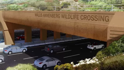
World's Largest Wildlife Overpass In the Works in Los Angeles County
Caltrans will soon close half of the 101 Freeway in order to continue construction of the Wallis Annenberg Wildlife Crossing near Agoura Hills in Los Angeles County.

California Grid Runs on 100% Renewable Energy for Over 9 Hours
The state’s energy grid was entirely powered by clean energy for some portion of the day on 37 out of the last 45 days.

New Forecasting Tool Aims to Reduce Heat-Related Deaths
Two federal agencies launched a new, easy-to-use, color-coded heat warning system that combines meteorological and medical risk factors.

AI Traffic Management Comes to Dallas-Fort Worth
Several Texas cities are using an AI-powered platform called NoTraffic to help manage traffic signals to increase safety and improve traffic flow.
City of Costa Mesa
Licking County
Barrett Planning Group LLC
HUD's Office of Policy Development and Research
Mpact Transit + Community
HUD's Office of Policy Development and Research
Tufts University, Department of Urban and Environmental Policy & Planning
City of Universal City TX
ULI Northwest Arkansas
Urban Design for Planners 1: Software Tools
This six-course series explores essential urban design concepts using open source software and equips planners with the tools they need to participate fully in the urban design process.
Planning for Universal Design
Learn the tools for implementing Universal Design in planning regulations.


