


California Governor Arnold Schwarzenegger signs a bill that institutionalizes form-based zoning for the first time in California history.

 On July 20, 2004, California Governor Arnold Schwarzenegger signed a bill that places "form-based zoning" into state statutes that regulate how California develops. Assembly Bill 1268 (Wiggins) institutionalizes form-based zoning for the first time in California history.
Although California's Government Code does not currently preclude form-based planning and zoning, the current language of the general plan law certainly does nothing to encourage mixing uses or seriously considering urban form and design along with land use. Section 65302 currently states:
"The general plan shall consist of a statement of development policies and shall include a diagram or diagrams and text setting forth objectives, principles, standards, and plan proposals. The plan shall include the following elements: (a) A land use element that designates the proposed general distribution and general location and extent of the uses of the land for housing, business, industry, open space, including agriculture, natural resources, recreation, and enjoyment of scenic beauty, education, public buildings and grounds, solid and liquid waste disposal facilities, and other categories of public and private uses of land."
For decades, most cities have taken this language literally, laying out areas for housing, for example, that are separate from areas for business and separate from every other land use. Most of us know that this has created the now all-too-familiar lifeless, sprawling, auto-oriented neighborhoods, towns and cities throughout California and the U.S. This conventional practice has created places where no one can walk to the store, to services or to work even if they wanted to, because the uses are so far apart and the streets are so hostile to pedestrians. Because of AB 1268, planning students will now be introduced to new language that formally allows mixed-uses and supports the regulation of relationships between the buildings and the streets. This new language will be in Government Code Section 65302.4 as follows:
"The text and diagrams in the land use element that address the location and extent of land uses, and the zoning ordinances that implement these provisions, may also express community intentions regarding urban form and design. These expressions may differentiate neighborhoods, districts, and corridors, provide for a mixture of land uses and housing types within each, and provide specific measures for regulating relationships between buildings, and between buildings and outdoor public areas, including streets."
It's an exciting time for planners in California. But it all came about because of a less-than-exciting experience in a small California city. Although the community and elected officials fully supported the walkable, community-based concepts of a form-based code, the city attorney questioned whether it was legal. This eventually led to a meeting with the Bay Area New Urbanists and Congress for the New Urbanism co-founder Andres Duany at the California Governor's Office of Planning and Research in Sacramento. At the meeting the Bay Area New Urbanists were invited to write a White Paper on the challenges faced by advocates of New Urbanism and Smart Growth in California's current planning environment.
This led to the paper titled, "White Paper on Smart Growth Policy in California" (PDF, 947 KB). The paper explained the structural obstacles to creating walkable, mixed-use communities in the State. The paper contained the language (page 6) that eventually became the basis for AB 1268.
California New Urbanists are excited about this bill because it removes all doubt that community plans and zoning codes in California can go beyond conventional land use planning and zoning techniques to make it easier to create great places.
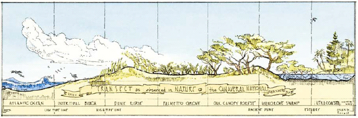
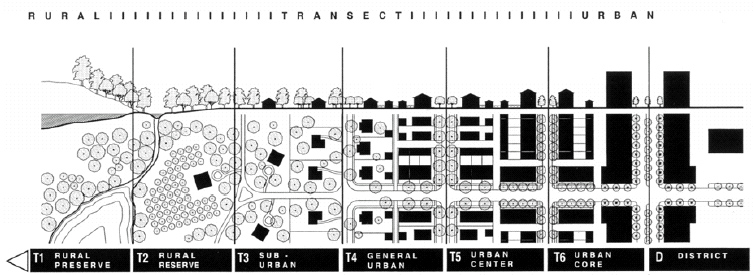
There is a comprehensive design theory that organizes the full continuum of human environments, from remote wilderness to dense downtowns. This system, known as the Transect, now guides the planning and design of many new villages, towns and cities, and is the framework for development codes now being adopted by counties in several states. The Transect is a concept drawn from ecology. It is a geographical cross section through a sequence of contiguous environments – for example, from wetland to upland, or tundra to foothill. The Transect can be extended from the natural environments into to the human habitat by introducing settlements of gradually increasing density. (Images and text from White Paper on Smart Growth Policy in California, Appendix B, 2004)
Laura Hall is a partner with Fisher & Hall Urban Design of Santa Rosa, California. Her firm crafted the Central Petaluma SmartCode, the first SmartCode in the U.S. Paul Crawford, FAICP, is a principal with Crawford Multari & Clark Associates of San Luis Obispo, California, which contributed to the Central Petaluma SmartCode. They are both members of the Bay Area New Urbanists.

Pennsylvania Mall Conversion Bill Passes House
If passed, the bill would promote the adaptive reuse of defunct commercial buildings.

Coming Soon to Ohio: The Largest Agrivoltaic Farm in the US
The ambitious 6,000-acre project will combine an 800-watt solar farm with crop and livestock production.

U.S. Supreme Court: California's Impact Fees May Violate Takings Clause
A California property owner took El Dorado County to state court after paying a traffic impact fee he felt was exorbitant. He lost in trial court, appellate court, and the California Supreme Court denied review. Then the U.S. Supreme Court acted.

How Freeway Projects Impact Climate Resilience
In addition to displacement and public health impacts, highway expansions can also make communities less resilient to flooding and other climate-related disasters.

California Grid Runs on 100% Renewable Energy for Over 9 Hours
The state’s energy grid was entirely powered by clean energy for some portion of the day on 37 out of the last 45 days.

New Forecasting Tool Aims to Reduce Heat-Related Deaths
Two federal agencies launched a new, easy-to-use, color-coded heat warning system that combines meteorological and medical risk factors.
City of Costa Mesa
Licking County
Barrett Planning Group LLC
HUD's Office of Policy Development and Research
Mpact Transit + Community
HUD's Office of Policy Development and Research
Tufts University, Department of Urban and Environmental Policy & Planning
City of Universal City TX
ULI Northwest Arkansas
Write for Planetizen
Urban Design for Planners 1: Software Tools
This six-course series explores essential urban design concepts using open source software and equips planners with the tools they need to participate fully in the urban design process.
Planning for Universal Design
Learn the tools for implementing Universal Design in planning regulations.