


The needs that drive complete streets policy are as unique as the communities they have taken root, but effective complete streets programs do share a few common traits.

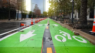
"The concept of complete streets places the same priority on pedestrians, bicyclists and public transport users as on motorists," according to an article by Anna Bray Sharpin, Ben Welle, and Nikita Luke for TheCityFix that provides a guide to the core components of complete streets in the many global examples of complete streets programs. There are a lot of examples to choose from, according to the article, as "more than 1,140 agencies at the local, regional, and state levels have adopted complete streets policies in the United States, totalling more than 1,200 policies nationwide." And the idea has been translated around the world. "They are the so-called calles completas in Mexico, ruas completas in Brazil, and “streets for all” in India."
The post lists eight key elements to complete streets, listed below but detailed with more specificity in the article:
- An Active Streetscape
- Pedestrian-Scale Lighting
- Green Infrastructure
- Street Furniture
- Bicycle Facilities
- Signage
- Accessibility for All
- Surface Types
FULL STORY: What Makes a Complete Street? A Brief Guide

Rochester Shows Possible Future for Former Highways
A former freeway is undergoing a massive redevelopment that goes beyond highway removal to reconnect and revitalize surrounding areas.

Meet NYC’s New Office of Livable Streets
The NYC DOT program will build on pandemic-era initiatives to promote safe and comfortable streets that enhance community and expand uses beyond just moving cars.
Houston Mayor Pauses Complete Streets Projects
The move raises concerns among road safety advocates who point out that traffic deaths continue to rise.

Pennsylvania Mall Conversion Bill Passes House
If passed, the bill would promote the adaptive reuse of defunct commercial buildings.

Coming Soon to Ohio: The Largest Agrivoltaic Farm in the US
The ambitious 6,000-acre project will combine an 800-watt solar farm with crop and livestock production.

World's Largest Wildlife Overpass In the Works in Los Angeles County
Caltrans will soon close half of the 101 Freeway in order to continue construction of the Wallis Annenberg Wildlife Crossing near Agoura Hills in Los Angeles County.

California Grid Runs on 100% Renewable Energy for Over 9 Hours
The state’s energy grid was entirely powered by clean energy for some portion of the day on 37 out of the last 45 days.

New Forecasting Tool Aims to Reduce Heat-Related Deaths
Two federal agencies launched a new, easy-to-use, color-coded heat warning system that combines meteorological and medical risk factors.

AI Traffic Management Comes to Dallas-Fort Worth
Several Texas cities are using an AI-powered platform called NoTraffic to help manage traffic signals to increase safety and improve traffic flow.
City of Costa Mesa
Licking County
Barrett Planning Group LLC
HUD's Office of Policy Development and Research
Mpact Transit + Community
HUD's Office of Policy Development and Research
Tufts University, Department of Urban and Environmental Policy & Planning
City of Universal City TX
ULI Northwest Arkansas
Urban Design for Planners 1: Software Tools
This six-course series explores essential urban design concepts using open source software and equips planners with the tools they need to participate fully in the urban design process.
Planning for Universal Design
Learn the tools for implementing Universal Design in planning regulations.